Approximate Location Map
Large Map »
Latitude: 53.4541 / 53°27'14"N
Longitude: -2.0102 / 2°0'36"W
OS Eastings: 399422
OS Northings: 395257
OS Grid: SJ994952
Mapcode National: GBR GXDH.LJ
Mapcode Global: WHB9S.3F1W
Plus Code: 9C5VFX3Q+JW
Entry Name: Gatepiers, Railings, Steps and Walls to Graveyard of St Michael and All Angels
Listing Date: 20 April 1977
Grade: II
Source: Historic England
Source ID: 1068029
English Heritage Legacy ID: 212548
ID on this website: 101068029
Location: St Michael and All Angels Church, Mudd, Tameside, Greater Manchester, SK14
County: Tameside
Electoral Ward/Division: Longdendale
Parish: Non Civil Parish
Built-Up Area: Glossop
Traditional County: Cheshire
Lieutenancy Area (Ceremonial County): Greater Manchester
Church of England Parish: Mottram-in-Longdendale St Michael
Church of England Diocese: Chester
Tagged with: Gatepost Railing Stairs Churchyard wall
SJ 99 NE LONGDENDALE WAR HILL
4/88 Gatepiers,
railings, steps
and walls to
graveyard of
St. Michael and
20.4.77 All Angels
G.V. II
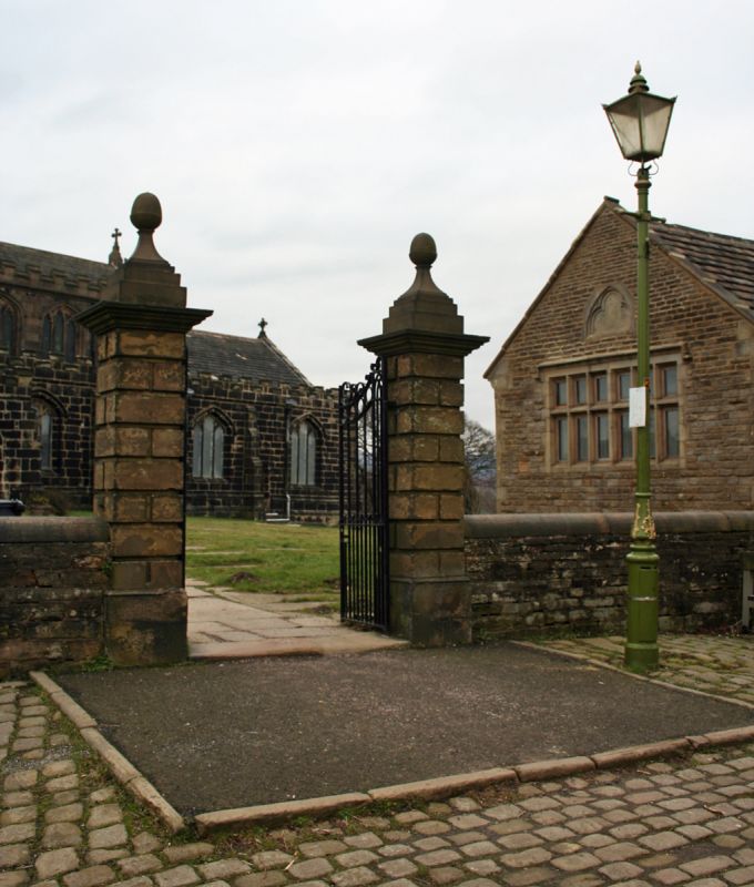
Gatepiers, railings, steps and graveyard walls. Gatepiers:
probably 1815: 2 pairs which are rusticated ashlar, have
bases and cornices, one of which is terminated in acorn
finials. The iron railings which adjoin the west gateposts
are terminated in a similar pier. The gates are in
decorative ironwork. The stone steps to the west have a
right-angled flight: the parapet walls are in squared rubble
and 2 of the coping stones bear the dates 1857 and 1734.
The walls of the graveyard are of squared rubble and hammer-
dressed stone and date largely form the C18. Datestones
incorporated in the wall include TBM 1769, 1804, 1815 and
1823. The round-topped coping stones are numbered 1-33
consecutively on the west and east sides and A-Z on the
north defining the graveyard plot layout. A weathered
buttress supports the wall (which is a retaining wall in
parts) at the south-west.
Listing NGR: SJ9942295257
External links are from the relevant listing authority and, where applicable, Wikidata. Wikidata IDs may be related buildings as well as this specific building. If you want to add or update a link, you will need to do so by editing the Wikidata entry.


Other nearby listed buildings
