Approximate Location Map
Large Map »
Latitude: 53.3987 / 53°23'55"N
Longitude: -2.9704 / 2°58'13"W
OS Eastings: 335570
OS Northings: 389535
OS Grid: SJ355895
Mapcode National: GBR 77R.FN
Mapcode Global: WH877.BTRV
Plus Code: 9C5V92XH+FR
Entry Name: 1-19 Canning Street
Listing Date: 28 June 1952
Last Amended: 19 June 1985
Grade: II
Source: Historic England
Source ID: 1068363
English Heritage Legacy ID: 213811
ID on this website: 101068363
Location: Liverpool, Merseyside, L8
County: Liverpool
Electoral Ward/Division: Princes Park
Parish: Non Civil Parish
Built-Up Area: Liverpool
Traditional County: Lancashire
Lieutenancy Area (Ceremonial County): Merseyside
Church of England Parish: St Luke in the City Team
Church of England Diocese: Liverpool
Tagged with: Building
SJ 3589 NE
57/196
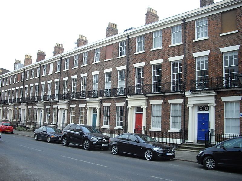
CANNING STREET (north side) L8
Nos. 1 to 19 (odd)
(formerly listed with Nos. 21 to 43 (odd))
28.06.52
G.V.
II
Terrace of ten houses.1830s. Brick with stone dressings, slate roof. Three storeys with basement, three bays to each house. Basement lintel band; first-floor sill band; top frieze, cornice and blocking course. Windows have wedge lintels and are sashed, with glazing bars above ground floor. One second-floor blind window to each house. Entrances have Ionic aedicules (no pediments). Plain iron railings to areas and steps.
No. 1 has complete overlight and six-panel door. No. 3 has six-panel door, No. 5 has complete overlight and six-panel door. No. 7 has complete overlight and four-panel door. No. 9 is the same and has first-floor iron balcony. No 11 has four-panel door and three iron balconies to first floor. No. 15 is the same. Nos. 17 and 19 have iron balconies to first floor.
Listing NGR: SJ3557089535
External links are from the relevant listing authority and, where applicable, Wikidata. Wikidata IDs may be related buildings as well as this specific building. If you want to add or update a link, you will need to do so by editing the Wikidata entry.


Other nearby listed buildings
