Latitude: 53.4023 / 53°24'8"N
Longitude: -2.9645 / 2°57'52"W
OS Eastings: 335972
OS Northings: 389928
OS Grid: SJ359899
Mapcode National: GBR 78Q.QC
Mapcode Global: WH877.FRK3
Plus Code: 9C5VC22P+W6
Entry Name: 14, Abercromby Square
Listing Date: 28 June 1952
Grade: II
Source: Historic England
Source ID: 1068437
English Heritage Legacy ID: 213597
ID on this website: 101068437
Location: Edge Hill, Liverpool, Merseyside, L69
County: Liverpool
Electoral Ward/Division: Central
Parish: Non Civil Parish
Built-Up Area: Liverpool
Traditional County: Lancashire
Lieutenancy Area (Ceremonial County): Merseyside
Church of England Parish: St Luke in the City Team
Church of England Diocese: Liverpool
Tagged with: Building
SJ 3589 NE ABERCROMBY
SQUARE
(South side)
L7
57/7 No.14
(formerly listed
with Nos. 8 to 13
28.6.52 (consec)
G.V. II
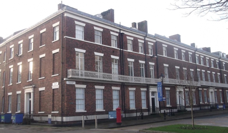
House. c.1830. Brick with stone dressings, slate roof. 3
storeys with basement, 3 bays. Basement lintel band, sill
bands and top frieze, cornice and blocking course. Windows
have wedge lintels and are sashed with glazing bars, except
1st floor windows, which have casements. Entrance has angle
pilasters, entablature complete overlight and 6-panel door.
1st floor iron balcony and plain iron area railings.
Listing NGR: SJ3590489932
External links are from the relevant listing authority and, where applicable, Wikidata. Wikidata IDs may be related buildings as well as this specific building. If you want to add or update a link, you will need to do so by editing the Wikidata entry.


Other nearby listed buildings