Approximate Location Map
Large Map »
Latitude: 50.9885 / 50°59'18"N
Longitude: 0.97 / 0°58'12"E
OS Eastings: 608540
OS Northings: 125215
OS Grid: TR085252
Mapcode National: GBR T03.S3K
Mapcode Global: FRA D6XH.PQ2
Plus Code: 9F22XXQC+C2
Entry Name: Former Water Tower
Listing Date: 21 May 1973
Grade: II
Source: Historic England
Source ID: 1069002
English Heritage Legacy ID: 175060
ID on this website: 101069002
Location: Littlestone-on-Sea, Folkestone and Hythe, Kent, TN28
County: Kent
District: Folkestone and Hythe
Civil Parish: New Romney
Built-Up Area: New Romney
Traditional County: Kent
Lieutenancy Area (Ceremonial County): Kent
Tagged with: Tower Water tower Residential building
1.
1449 MADEIRA ROAD
LITTLESTONE-ON-SEA
(West Side)
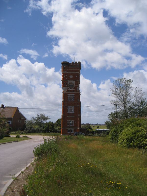
Former Water Tower
TR 02 NE 3/77
II
2.
Dated 1890. A tall square-shaped tower of 6 storeys built of red brick with
brick and stone buttresses. Octagonal staircase turret from 4th storey to roof
having arrow slit windows. Crenellated parapet. 1 to 2 windows on each side.
On the ground floor there are 2 casements. On the 1st and 2nd floors there is
1 3-light sash, that on the 2nd floor set in a Tudor arched head. The 3rd floor
has 1 3-light sash. The 4th floor originally had a round window but this has
now been filled in with brickwork to form a small fixed window.
Listing NGR: TR0854025215
External links are from the relevant listing authority and, where applicable, Wikidata. Wikidata IDs may be related buildings as well as this specific building. If you want to add or update a link, you will need to do so by editing the Wikidata entry.


Other nearby listed buildings
