Latitude: 51.3021 / 51°18'7"N
Longitude: 0.6891 / 0°41'20"E
OS Eastings: 587550
OS Northings: 159319
OS Grid: TQ875593
Mapcode National: GBR QSD.71Q
Mapcode Global: VHJM9.WJNP
Plus Code: 9F328M2Q+RJ
Entry Name: Swanton Street Farmhouse
Listing Date: 27 August 1952
Grade: II*
Source: Historic England
Source ID: 1069371
English Heritage Legacy ID: 176122
ID on this website: 101069371
Location: Swanton Street, Swale, Kent, ME9
County: Kent
District: Swale
Civil Parish: Bredgar
Traditional County: Kent
Lieutenancy Area (Ceremonial County): Kent
Tagged with: Farmhouse
TQ 85 NE BREDGAR SWANTON STREET (west side)
7/6 Swanton Street 27.8.52 Farmhouse
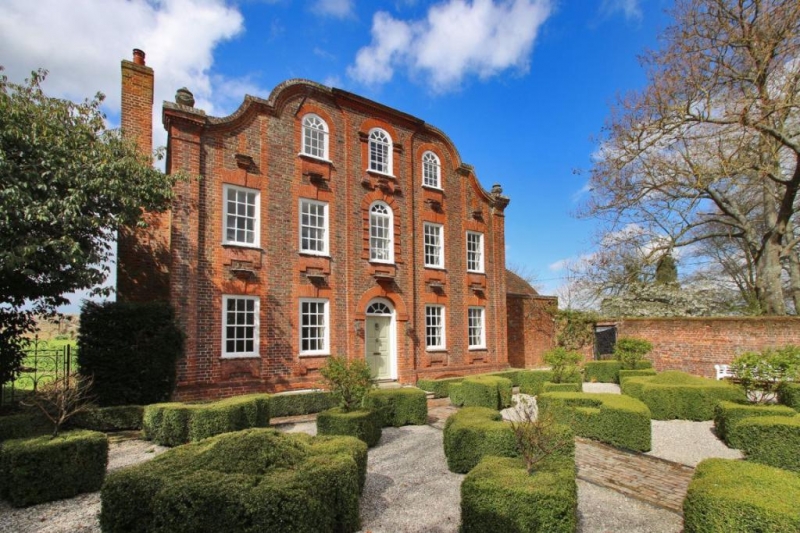
GV II* Farmhouse. Front of 1719 to earlier building. Brown brick with red brick dressings and plain tiled roof. Three storeys and basement on plinth with giant pilasters to left and right projecting central bay and splayed at top shaped parapet gable with hipped roof and stacks to left and right. Regular fenestration of 3 semi-circular headed wood casements on top floor, 5 glazing bar sash on first floor, the central with semi-circular fan light over and keyed and rusticated surrounds, and 4 glazing bar sash on ground floor. Apart from the central window, all windows with aprons and gauged heads with keystones developed into large brackets. Central door of 6 raised and fielded panels with semi-circular fanlight with keyed and gauged surround at head of flight of 3 steps. Basement openings to left and right, 1 storey red brick extension to right. Keystone to door inscribed: EH 17 19 Interior: full pine-panelled rooms, original early C18 staircase turned balusters and curved hand rail. The 1719 work done for Edward Holliday, a London goldsmith. (See B.O.E. Kent II, 1983, 158. Also K. Downes, English Baroque Architecture, London 1966).
Listing NGR: TQ8769659476
External links are from the relevant listing authority and, where applicable, Wikidata. Wikidata IDs may be related buildings as well as this specific building. If you want to add or update a link, you will need to do so by editing the Wikidata entry.


Other nearby listed buildings