Latitude: 51.3144 / 51°18'51"N
Longitude: 0.8912 / 0°53'28"E
OS Eastings: 601582
OS Northings: 161221
OS Grid: TR015612
Mapcode National: GBR SW3.J43
Mapcode Global: VHKJW.D7H7
Plus Code: 9F328V7R+QF
Entry Name: 77, Preston Street
Listing Date: 3 August 1972
Grade: II
Source: Historic England
Source ID: 1069447
English Heritage Legacy ID: 175996
ID on this website: 101069447
Location: Faversham, Swale, Kent, ME13
County: Kent
District: Swale
Civil Parish: Faversham
Built-Up Area: Faversham
Traditional County: Kent
Lieutenancy Area (Ceremonial County): Kent
Tagged with: Building
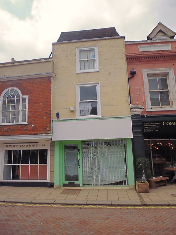
PRESTON STREET
1.
1103 (West Side)
--------------
No 77
TR 0161 SE 3/63
II GV
2.
Early Cl9 front to a C17 timber-framed building. Narrow frontage. 3
storeys, 1 window. Stuccoed. Parapet. Steeply pitched tiled roof
with gable at ends. Glazing bars missing. Modern shop front. Photo-
graph in NMR.
Nos 73 to 78 (consec) and No 78A form a group.
Listing NGR: TR0157461223
External links are from the relevant listing authority and, where applicable, Wikidata. Wikidata IDs may be related buildings as well as this specific building. If you want to add or update a link, you will need to do so by editing the Wikidata entry.


Other nearby listed buildings