Latitude: 51.2483 / 51°14'53"N
Longitude: 1.3026 / 1°18'9"E
OS Eastings: 630581
OS Northings: 155081
OS Grid: TR305550
Mapcode National: GBR X1F.L60
Mapcode Global: VHLGR.JWJG
Plus Code: 9F3368X3+83
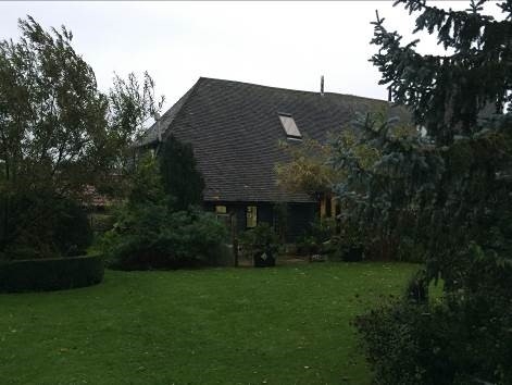
Entry Name: Barn About 30 Metres South West of Gore Court
Listing Date: 26 November 1987
Last Amended: 13 May 1989
Grade: II
Source: Historic England
Source ID: 1070175
English Heritage Legacy ID: 178162
ID on this website: 101070175
Location: Gore, Dover, Kent, CT13
County: Kent
District: Dover
Civil Parish: Eastry
Built-Up Area: Eastry
Traditional County: Kent
Lieutenancy Area (Ceremonial County): Kent
Tagged with: Barn
In the entry for
6/131
EASTRY
GORE LANE
(west side)
Barn about 30 metres south-west of Gore House
The address shall be amended to read:
TR 35 NW
6/131
26.11.87
EASTRY
GORE LANE
(west side)
Barn about 30 metres south-west of Gore Court
------------------------------------
TR 35 NW
6/131
EASTRY
GORE LANE
(west side)
Barn about 30 metres south-west of Gore House
GV
II
Barn. C17. Timber framed and clad with weather boarding with corrugated iron
roof. Half-hipped roof with raking mid-strey. Interior; 3 bays with aisles,
with passing shores to arcade posts. Clasped purlin roof.
Listing NGR: TR3058155081
External links are from the relevant listing authority and, where applicable, Wikidata. Wikidata IDs may be related buildings as well as this specific building. If you want to add or update a link, you will need to do so by editing the Wikidata entry.


Other nearby listed buildings