Approximate Location Map
Large Map »
Latitude: 51.2111 / 51°12'39"N
Longitude: 0.7951 / 0°47'42"E
OS Eastings: 595326
OS Northings: 149474
OS Grid: TQ953494
Mapcode National: GBR RW0.3T8
Mapcode Global: VHKK6.QTQG
Plus Code: 9F326Q6W+C2
Entry Name: Old School House
Listing Date: 10 October 1980
Grade: II
Source: Historic England
Source ID: 1070754
English Heritage Legacy ID: 180761
ID on this website: 101070754
Location: Charing, Ashford, Kent, TN27
County: Kent
District: Ashford
Civil Parish: Charing
Built-Up Area: Charing
Traditional County: Kent
Lieutenancy Area (Ceremonial County): Kent
Tagged with: House
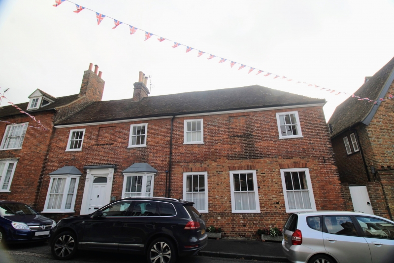
1.
5272 CHARING HIGH STREET
(east side)
Old School House an d
No 64
TQ 9549 22/14
II GV
2.
C18. Two storeys red brick. Tiled roof with moulded wooden eaves cornice.
Four sashes and 2 window spaces, with glazing bars intact on the first floor
only. Old School House has two C19 3-light canted bays on the ground floor
and a doorcase with cornice and brackets. No 64 has a modern shop-front.
Listing NGR: TQ9532449471
External links are from the relevant listing authority and, where applicable, Wikidata. Wikidata IDs may be related buildings as well as this specific building. If you want to add or update a link, you will need to do so by editing the Wikidata entry.


Other nearby listed buildings
