Approximate Location Map
Large Map »
Latitude: 51.0497 / 51°2'58"N
Longitude: 0.6354 / 0°38'7"E
OS Eastings: 584814
OS Northings: 131116
OS Grid: TQ848311
Mapcode National: GBR QWD.5FV
Mapcode Global: FRA D66B.Z7Y
Plus Code: 9F322JXP+V5
Entry Name: Bull Farmhouse
Listing Date: 9 August 1979
Grade: II
Source: Historic England
Source ID: 1070929
English Heritage Legacy ID: 180362
ID on this website: 101070929
Location: Rolvenden, Ashford, Kent, TN17
County: Kent
District: Ashford
Civil Parish: Rolvenden
Built-Up Area: Rolvenden
Traditional County: Kent
Lieutenancy Area (Ceremonial County): Kent
Tagged with: Farmhouse
ROLVENDEN MAYTHAM ROAD
1.
5272
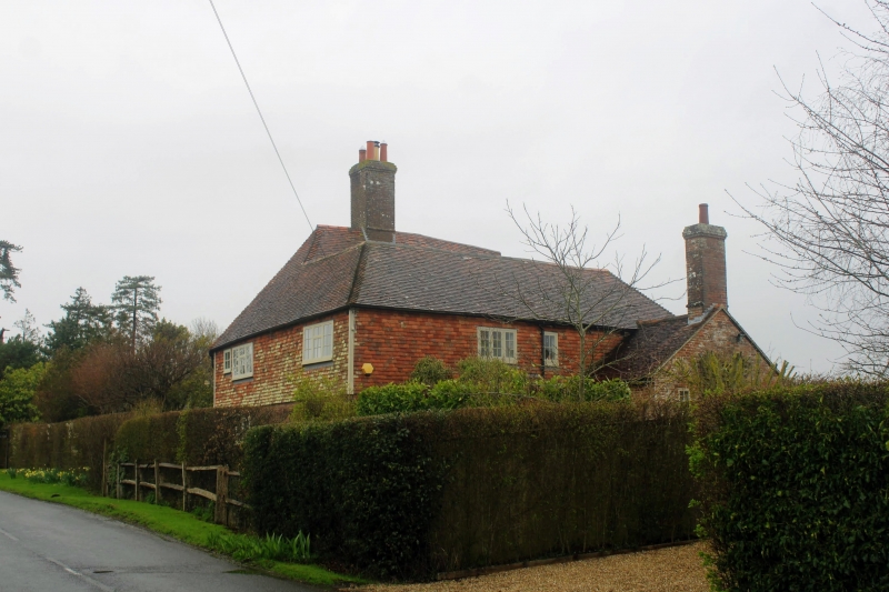
Bull Farmhouse
TQ 8431 18/317
II
2.
Probably C15 timber framed L-shaped building now tile hung except for the
ground floor of the east front which is of red brick. Two storeys. Steeply-
pitched hipped tiled roof. Three windows facing north, 2 windows facing east,
the southernmost of these window bays added. Some casement windows, some
sash windows with glazing bars intact.
Listing NGR: TQ8481431116
External links are from the relevant listing authority and, where applicable, Wikidata. Wikidata IDs may be related buildings as well as this specific building. If you want to add or update a link, you will need to do so by editing the Wikidata entry.


Other nearby listed buildings
