Approximate Location Map
Large Map »
Latitude: 51.2892 / 51°17'21"N
Longitude: 0.286 / 0°17'9"E
OS Eastings: 559502
OS Northings: 156935
OS Grid: TQ595569
Mapcode National: GBR XH.QS7
Mapcode Global: VHHPM.XV2K
Plus Code: 9F3277QP+MC
Entry Name: Chest Tomb 10 Yards East of Church of St Peter
Listing Date: 3 May 1984
Grade: II
Source: Historic England
Source ID: 1071963
English Heritage Legacy ID: 357244
ID on this website: 101071963
Location: St Peter's Church, Ightham, Tonbridge and Malling, Kent, TN15
County: Kent
District: Tonbridge and Malling
Civil Parish: Ightham
Built-Up Area: Ightham
Traditional County: Kent
Lieutenancy Area (Ceremonial County): Kent
Church of England Parish: Ightham St Peter
Church of England Diocese: Rochester
Tagged with: Chest tomb
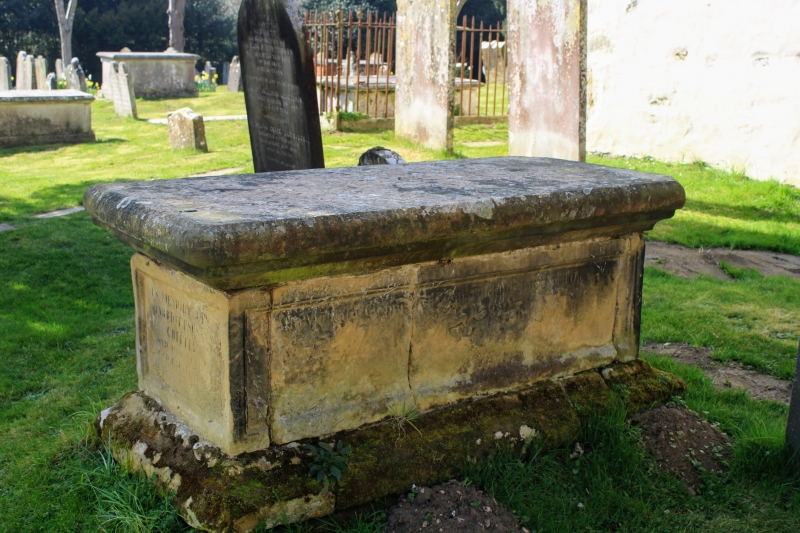
TQ 5956 IGHTHAM FEN POND ROAD
5/4 (west side)
Chest Tomb 10 yds
east of Church of
St Peter
GV
II
Chest tomb. Early C19. Stone with panelled sides. Inscribed (partly illegible),
William,? died 1807.
Listing NGR: TQ5949856934
External links are from the relevant listing authority and, where applicable, Wikidata. Wikidata IDs may be related buildings as well as this specific building. If you want to add or update a link, you will need to do so by editing the Wikidata entry.


Other nearby listed buildings
