Approximate Location Map
Large Map »
Latitude: 51.2568 / 51°15'24"N
Longitude: 0.3126 / 0°18'45"E
OS Eastings: 561464
OS Northings: 153394
OS Grid: TQ614533
Mapcode National: GBR NPT.1V0
Mapcode Global: VHHPV.CNLV
Plus Code: 9F327847+P2
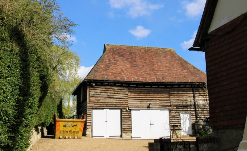
Entry Name: Barn 30 Yards to the East of Old Allens
Listing Date: 1 August 1952
Grade: II
Source: Historic England
Source ID: 1072680
English Heritage Legacy ID: 357325
ID on this website: 101072680
Location: Plaxtol, Tonbridge and Malling, Kent, TN15
County: Kent
District: Tonbridge and Malling
Town: Tonbridge and Malling
Civil Parish: Plaxtol
Traditional County: Kent
Lieutenancy Area (Ceremonial County): Kent
Church of England Parish: Plaxtol
Church of England Diocese: Rochester
Tagged with: Barn
TQ 65 SW PLAXTOL ALLENS LAND
4/24 (east side)
1.8.52 Barn 30 yds to the
east of Old Allens
GV
II
Barn. C18. Weatherboarded. Hipped plain tiled roof with gablets. No waggon
entrance. Three bays.
Listing NGR: TQ6145053383
External links are from the relevant listing authority and, where applicable, Wikidata. Wikidata IDs may be related buildings as well as this specific building. If you want to add or update a link, you will need to do so by editing the Wikidata entry.


Other nearby listed buildings
