Latitude: 53.6169 / 53°37'0"N
Longitude: -2.7174 / 2°43'2"W
OS Eastings: 352638
OS Northings: 413615
OS Grid: SD526136
Mapcode National: GBR 9VGM.H5
Mapcode Global: WH86D.7C71
Plus Code: 9C5VJ78M+Q2
Entry Name: Church of St James
Listing Date: 19 August 1988
Grade: II
Source: Historic England
Source ID: 1073009
English Heritage Legacy ID: 357871
ID on this website: 101073009
Location: St James's Church, Wrightington Bar, West Lancashire, WN6
County: Lancashire
District: West Lancashire
Civil Parish: Wrightington
Traditional County: Lancashire
Lieutenancy Area (Ceremonial County): Lancashire
Church of England Parish: Wrightington with Heskin St James the Great
Church of England Diocese: Blackburn
Tagged with: Church building Gothic Revival
WRIGHTINGTON CHURCH LANE
SD 51 SW
5/95 Church of St James
-
II
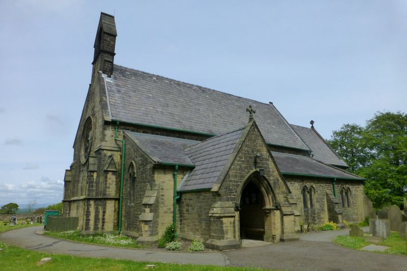
Church. 1857 by E.G. Paley. Snecked sandstone rubble with slate roof.
Comprises a nave, south aisle and porch, and lower chancel. West wall has
wheel window and gabled bellcote. North wall of nave of 4 bays which have
paired lancets and are separated by buttresses. South aisle has 3 bays to
east of porch with similar windows. Outer porch doorway is chamfered in 2
orders. Chancel has 2 lancet windows to south and triple stepped lancets
at east. Interior: 4-bay arcade of pointed arches chamfered in 2 orders
springing from alternate round and octagonal piers. Open timber roof.
Listing NGR: SD5263813615
External links are from the relevant listing authority and, where applicable, Wikidata. Wikidata IDs may be related buildings as well as this specific building. If you want to add or update a link, you will need to do so by editing the Wikidata entry.


Other nearby listed buildings