Approximate Location Map
Large Map »
Latitude: 53.9016 / 53°54'5"N
Longitude: -2.1732 / 2°10'23"W
OS Eastings: 388714
OS Northings: 445060
OS Grid: SD887450
Mapcode National: GBR FR8B.94
Mapcode Global: WHB7K.L6B9
Plus Code: 9C5VWR2G+JP
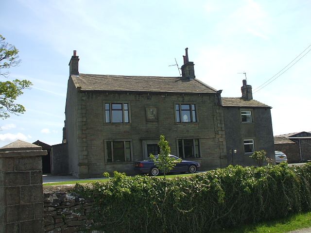
Entry Name: Higher Green Hall Farmhouse
Listing Date: 10 September 1954
Grade: II
Source: Historic England
Source ID: 1073355
English Heritage Legacy ID: 186385
ID on this website: 101073355
Location: Salterforth, Pendle, Lancashire, BB18
County: Lancashire
District: Pendle
Civil Parish: Salterforth
Traditional County: Yorkshire
Lieutenancy Area (Ceremonial County): Lancashire
Tagged with: Farmhouse
SD 84 NE SALTERFORTH SALTERFORTH LANE
3/220 Higher Green Hall
Farmhouse
10.9.54
- II
Farmhouse. W/IE/1768 over door. Dressed stone, stone slate roof. Two storeys,
three symmetrical bays. Ashlar quoins, stone gutter corbels, coping and
kneelers. 3-light window with flat faced surrounds and slightly recessed
mullions, the centred lights much broader. Plain surround to doorway. Gable
stacks.
Listing NGR: SD8871445060
External links are from the relevant listing authority and, where applicable, Wikidata. Wikidata IDs may be related buildings as well as this specific building. If you want to add or update a link, you will need to do so by editing the Wikidata entry.


Other nearby listed buildings
