Latitude: 54.2367 / 54°14'12"N
Longitude: -0.7198 / 0°43'11"W
OS Eastings: 483540
OS Northings: 483086
OS Grid: SE835830
Mapcode National: GBR RMDG.Z1
Mapcode Global: WHF9X.XRFZ
Plus Code: 9C6X67PJ+M3
Entry Name: Lady Lumley's Almshouses
Listing Date: 10 November 1953
Last Amended: 5 February 1986
Grade: II
Source: Historic England
Source ID: 1074192
English Heritage Legacy ID: 439927
ID on this website: 101074192
Location: Thornton-le-Dale, North Yorkshire, YO18
County: North Yorkshire
District: Ryedale
Civil Parish: Thornton-le-Dale
Built-Up Area: Thornton-le-Dale
Traditional County: Yorkshire
Lieutenancy Area (Ceremonial County): North Yorkshire
Tagged with: Almshouse
THORNTON DALE CHESTNUT AVENUE
SE 8383
(north side)
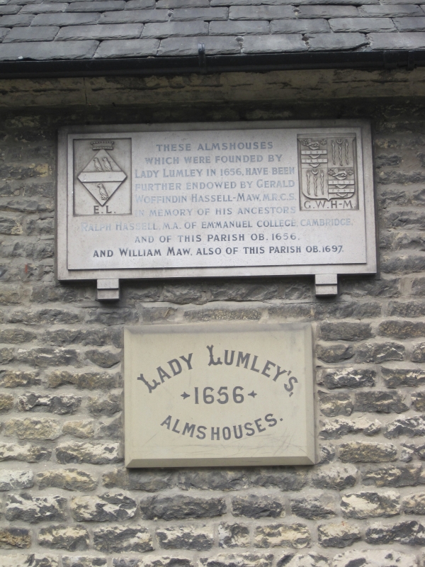
14/90 Lady Lumley's Almshouses
(Previously listed as
10.11.53 Almshouses).
GV II
Row of 12 almshouses. 1670; restored C19; modernised and extended C20.
Founded under the terms of a Trust Deed executed by Lady Elizabeth Lumley in
1657. Squared limestone with stone flag roof. Single-cell, lobby-entry
plan, with C20 rear extensions. Single storey, 24-bay front. Paired 4-
panel doors in plain square surrounds alternate to the left and right of 2-
light diamond lattice windows with cinquefoil heads in similar surrounds.
C19 tablet to centre recording the origins of The Charity. Moulded eaves
cornice. Seven ridge stacks. R W Jeffery, Thornton-le-Dale, 1931, p73 and
footnotes.
Listing NGR: SE8354083086
External links are from the relevant listing authority and, where applicable, Wikidata. Wikidata IDs may be related buildings as well as this specific building. If you want to add or update a link, you will need to do so by editing the Wikidata entry.


Other nearby listed buildings