Approximate Location Map
Large Map »
Latitude: 52.6203 / 52°37'13"N
Longitude: -1.1237 / 1°7'25"W
OS Eastings: 459423
OS Northings: 302865
OS Grid: SK594028
Mapcode National: GBR FJQ.WK
Mapcode Global: WHDJJ.QD3K
Plus Code: 9C4WJVCG+4G
Entry Name: Engineering Building, University of Leicester
Listing Date: 30 March 1993
Grade: II*
Source: Historic England
Source ID: 1074756
English Heritage Legacy ID: 188869
ID on this website: 101074756
Location: Clarendon Park, Leicester, Leicestershire, LE1
County: City of Leicester
Electoral Ward/Division: Castle
Parish: Non Civil Parish
Built-Up Area: Leicester
Traditional County: Leicestershire
Lieutenancy Area (Ceremonial County): Leicestershire
Church of England Parish: Leicester The Holy Spirit
Church of England Diocese: Leicester
Tagged with: University building
LEICESTER UNIVERSITY ROAD
SK 50 SE
17/10009 Engineering Building,
University of Leicester
II* (star)
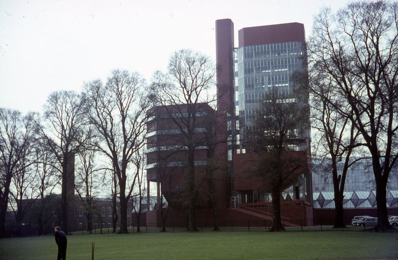
University engineering building. 1961-63. James Stirling and
James Gowan. Red engineering brick, red tile clad surfaces
and patent glazing; concrete frame; flat roofs to towers. Pair
of multi-storey towers, one for offices and one for research,
set above a pair of lecture theatres with raking undersides,
placed upon a brick podium. These are attached to a low
engineering workshop complex, mostly single storeyed but with
a taller section to south-west perimeter which has overhanging
upper storey above recessed gallery. Octagonal chimney rises
from midst of low workshop block. Complex, sculptural
composition; office tower fully glazed, (present glazing not
original); lower research tower with walls mostly of brick,
having narrow horizontal bands of glazing canted outwards to
each storey. Lecture theatres blind with tiled walls.
Engineering workshops with brick walls and roofs fully glazed
in a series of ridges at 45° to perimeter of block; perimeter
finished in a complex rhythm of chamfers, squares and points.
James stirling, 1950-1974, John Jacobus
(Thames and Hudson, 1975)
Listing NGR: SK5942302865
External links are from the relevant listing authority and, where applicable, Wikidata. Wikidata IDs may be related buildings as well as this specific building. If you want to add or update a link, you will need to do so by editing the Wikidata entry.


Other nearby listed buildings
