Approximate Location Map
Large Map »
Latitude: 52.8142 / 52°48'51"N
Longitude: -0.7803 / 0°46'49"W
OS Eastings: 482303
OS Northings: 324769
OS Grid: SK823247
Mapcode National: GBR CPS.FKF
Mapcode Global: WHFJV.ZJLF
Plus Code: 9C4XR679+MV
Entry Name: Church Farm
Listing Date: 31 August 1979
Last Amended: 26 February 1992
Grade: II
Source: Historic England
Source ID: 1074986
English Heritage Legacy ID: 190281
ID on this website: 101074986
Location: Stonesby, Melton, Leicestershire, LE14
County: Leicestershire
District: Melton
Civil Parish: Sproxton
Traditional County: Leicestershire
Lieutenancy Area (Ceremonial County): Leicestershire
Church of England Parish: Stonesby
Church of England Diocese: Leicester
Tagged with: Building
In the entry for
SK 8224 SPROXTON BACK LANE
(north side)
Stonesby
27/78 The Old Vicarage (formerly listed
31.8.79 as Former Vicarage)
GV II
The address shall be amended to read
SK 8224 SPROXTON BACK LANE
(north side)
Stonesby
27/78 Church Farm (No 22)
31.8.79
GV II
------------------------------------
SK 8224 SPROXTON BACK LANE
(North side)
Stonesby
27/78 The Old Vicarage (formerly
31.8.79 listed as Former Vicarage)
GV II
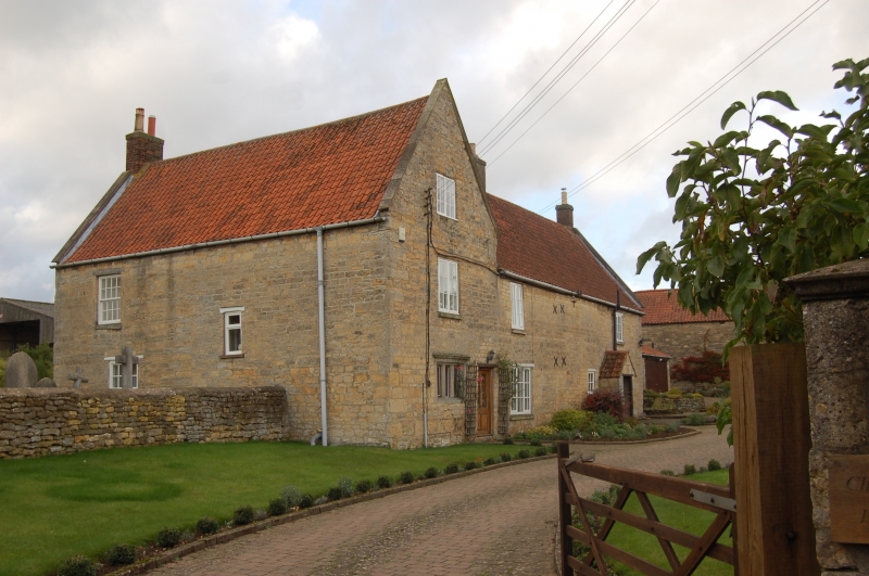
Private house, formerly vicarage. C17 south block, C18 rear range added
and rest remodelled. Further C20 alterations. Coursed ironstone and
pantile roofs. 2 storeys and attics. South block entered through door,
formerly with pediment, in east gable end. To left of door is one 3-light
C17 ovolo moulded mullioned stone window. All other windows are late C20.
One casement each floor above. 2 sashes and one casement irregularly
placed to south front. West gable has 3 blocked vertically orientated
windows, probably originally C18. Gabled roof with west internal end
stack. 2 storey cross wing extends north, in 3 wide bays of irregular
disposition. C20 gabled porch to door in north end of east side.
Fenestration of C20 casements. Gabled roof with a north gable-end stack
and a ridge stack further south.
Listing NGR: SK8230324769
External links are from the relevant listing authority and, where applicable, Wikidata. Wikidata IDs may be related buildings as well as this specific building. If you want to add or update a link, you will need to do so by editing the Wikidata entry.


Other nearby listed buildings
