Approximate Location Map
Large Map »
Latitude: 51.7618 / 51°45'42"N
Longitude: -0.56 / 0°33'36"W
OS Eastings: 499476
OS Northings: 207989
OS Grid: SP994079
Mapcode National: GBR F55.H77
Mapcode Global: VHFRY.7ZS9
Plus Code: 9C3XQC6Q+PX
Entry Name: The Boote
Listing Date: 9 May 1973
Grade: II
Source: Historic England
Source ID: 1078130
English Heritage Legacy ID: 355436
ID on this website: 101078130
Location: Dacorum, Hertfordshire, HP4
County: Hertfordshire
District: Dacorum
Civil Parish: Berkhamsted
Built-Up Area: Berkhamsted
Traditional County: Hertfordshire
Lieutenancy Area (Ceremonial County): Hertfordshire
Church of England Parish: Great Berkhamsted
Church of England Diocese: St.Albans
Tagged with: Building
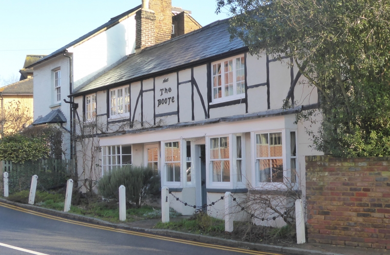
1.
839 CASTLE STREET
(East Side)
No 57 (The Boote)
SP 9907 NW 1/118
II
2.
Date 1605 on front. Stucco ground floor, timber frame and plaster 1st
floor, Welsh slated roof. 2 storeys, 3 1st floor casements with glazing
bars. 4 ground floor canted bay windows under continuous frieze and cornice;
glazing bars to bay on left.
Listing NGR: SP9947607989
External links are from the relevant listing authority and, where applicable, Wikidata. Wikidata IDs may be related buildings as well as this specific building. If you want to add or update a link, you will need to do so by editing the Wikidata entry.


Other nearby listed buildings
