Latitude: 51.5061 / 51°30'21"N
Longitude: -0.2056 / 0°12'20"W
OS Eastings: 524629
OS Northings: 180100
OS Grid: TQ246801
Mapcode National: GBR C8.SYX
Mapcode Global: VHGQY.DD4S
Plus Code: 9C3XGQ4V+CP
Entry Name: 35-67, Holland Park Mews W11
Listing Date: 15 April 1969
Grade: II
Source: Historic England
Source ID: 1080592
English Heritage Legacy ID: 203945
ID on this website: 101080592
Location: Notting Hill, Kensington and Chelsea, London, W11
County: London
District: Kensington and Chelsea
Electoral Ward/Division: Holland
Parish: Non Civil Parish
Built-Up Area: Kensington and Chelsea
Traditional County: Middlesex
Lieutenancy Area (Ceremonial County): Greater London
Church of England Parish: St George, Campden Hill
Church of England Diocese: London
Tagged with: Building
TQ 2480 SW TQ 2480 SE HOLLAND PARK MEWS W11 23/47 24/47 15.4.69 Nos 35 to 67 (consec)
II
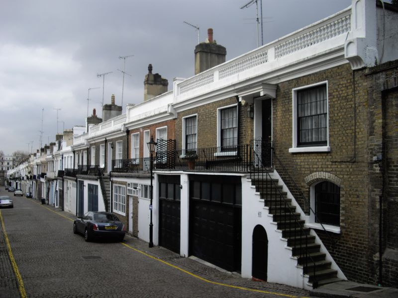
Mews. 1862. Two storeys, stock brick, built on steep slope and stepped down. Garage door to ground floor of each. Stone steps to downhill part of elevation, with iron railings. Segmental window on stairs, and segmental headed door below. Top floor with iron railed balcony across front, 2 sashes, and central door with fanlight. Stuccoed cornice and balustrade. Some houses unsuitably altered with ground floor remodelled or stairs removed. Some without balustrades. Buildings of unusual design and marked picturesqueness.
Listing NGR: TQ2462980100
External links are from the relevant listing authority and, where applicable, Wikidata. Wikidata IDs may be related buildings as well as this specific building. If you want to add or update a link, you will need to do so by editing the Wikidata entry.


Other nearby listed buildings