Approximate Location Map
Large Map »
Latitude: 51.6036 / 51°36'12"N
Longitude: 0.0193 / 0°1'9"E
OS Eastings: 539943
OS Northings: 191348
OS Grid: TQ399913
Mapcode National: GBR LM.PJP
Mapcode Global: VHHMY.9Y2K
Plus Code: 9F32J239+CP
Entry Name: Obelisk Opposite Number 1
Listing Date: 3 April 1973
Grade: II
Source: Historic England
Source ID: 1081023
English Heritage Legacy ID: 204801
ID on this website: 101081023
Location: Redbridge, London, IG8
County: London
District: Redbridge
Electoral Ward/Division: Church End
Parish: Non Civil Parish
Built-Up Area: Redbridge
Traditional County: Essex
Lieutenancy Area (Ceremonial County): Greater London
Church of England Parish: Woodford St Mary with St Philip and St James
Church of England Diocese: Chelmsford
Tagged with: Obelisk
BROOMHILL WALK
1.
5027
Woodford Green
Obelisk opposite
No 1
TQ 3991 8/2 3.4.73
II
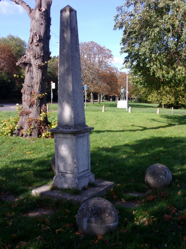
2.
Probably C19. Restored in 1977. Small Portland stone obelisk on an incised
base. Surrounded by 4 concrete balls.
Listing NGR: TQ3994391348
External links are from the relevant listing authority and, where applicable, Wikidata. Wikidata IDs may be related buildings as well as this specific building. If you want to add or update a link, you will need to do so by editing the Wikidata entry.


Other nearby listed buildings
