Approximate Location Map
Large Map »
Latitude: 52.0388 / 52°2'19"N
Longitude: -2.4244 / 2°25'27"W
OS Eastings: 370984
OS Northings: 237908
OS Grid: SO709379
Mapcode National: GBR FZ.FM7B
Mapcode Global: VH860.X0NW
Plus Code: 9C4V2HQG+G6
Entry Name: 64, the Homend
Listing Date: 5 November 1976
Grade: II
Source: Historic England
Source ID: 1082867
English Heritage Legacy ID: 151924
ID on this website: 101082867
Location: Ledbury, County of Herefordshire, HR8
County: County of Herefordshire
Civil Parish: Ledbury
Built-Up Area: Ledbury
Traditional County: Herefordshire
Lieutenancy Area (Ceremonial County): Herefordshire
Church of England Parish: Ledbury
Church of England Diocese: Hereford
Tagged with: Building
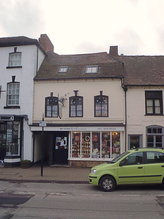
1.
5245 THE HOMEND
(West Side)
-----------
No 64
SO 7037 NW 2/65B
II GV
2.
C17 timber framed, exposed at rear. Stuccoed front. 2 storeys. 3 windows. Wood
mullion/transom casements with segmental arches and fluted keyblocks. Good Victorian
shop window with vertical bars and fascia. Panelled passage door on left in segmental-
headed doorcase, the door has fielded panels with round-headed top panels. Old
tiled roof with gable ends. Dentil eaves. Exposed timber framing at rear.
Nos 34 to 60 (even) and Nos 64 to 74 (even) form a group.
Listing NGR: SO7098437908
External links are from the relevant listing authority and, where applicable, Wikidata. Wikidata IDs may be related buildings as well as this specific building. If you want to add or update a link, you will need to do so by editing the Wikidata entry.


Other nearby listed buildings
