Approximate Location Map
Large Map »
Latitude: 53.6861 / 53°41'10"N
Longitude: -0.9991 / 0°59'56"W
OS Eastings: 466197
OS Northings: 421538
OS Grid: SE661215
Mapcode National: GBR PTGT.HC
Mapcode Global: WHFDH.MMF0
Plus Code: 9C5XM2P2+C9
Entry Name: Milepost Approximately 50 Metres South-East of Cowick Primary School
Listing Date: 16 December 1986
Grade: II
Source: Historic England
Source ID: 1083326
English Heritage Legacy ID: 164951
ID on this website: 101083326
Location: East Cowick, East Riding of Yorkshire, DN14
County: East Riding of Yorkshire
Civil Parish: Snaith and Cowick
Traditional County: Yorkshire
Lieutenancy Area (Ceremonial County): East Riding of Yorkshire
Church of England Parish: Great Snaith
Church of England Diocese: Sheffield
Tagged with: Milestone
SNAITH AND COWICK SNAITH ROAD
SE 62 SE
(south side)
East Cowick
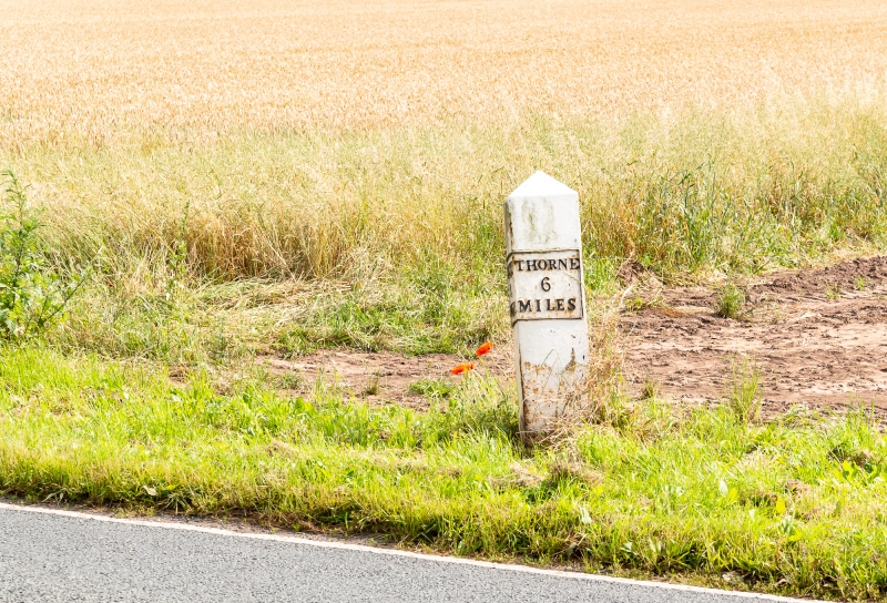
3/90 Mile-post approximately
50 metres south-east of
Cowick Primary School
GV II
Mile-post. Mid-late C19. Cast iron. Triangular in section, approximately
1.1 metres high, with triangular head. Panel to sides facing road has
raised border and inscription:
SELBY THORNE
9 6
MILES MILES
Listing NGR: SE6619721538
External links are from the relevant listing authority and, where applicable, Wikidata. Wikidata IDs may be related buildings as well as this specific building. If you want to add or update a link, you will need to do so by editing the Wikidata entry.


Other nearby listed buildings
