Approximate Location Map
Large Map »
Latitude: 51.1321 / 51°7'55"N
Longitude: 0.2698 / 0°16'11"E
OS Eastings: 558911
OS Northings: 139435
OS Grid: TQ589394
Mapcode National: GBR MPS.WKR
Mapcode Global: VHHQD.MSHZ
Plus Code: 9F3247J9+VW
Entry Name: 3, Calverley Park
Listing Date: 20 May 1952
Grade: II*
Source: Historic England
Source ID: 1083783
English Heritage Legacy ID: 167909
ID on this website: 101083783
Location: Royal Tunbridge Wells, Tunbridge Wells, Kent, TN1
County: Kent
District: Tunbridge Wells
Electoral Ward/Division: Park
Parish: Non Civil Parish
Built-Up Area: Royal Tunbridge Wells
Traditional County: Kent
Lieutenancy Area (Ceremonial County): Kent
Church of England Parish: Tunbridge Wells Holy Trinity with Christ Church
Church of England Diocese: Rochester
Tagged with: Building
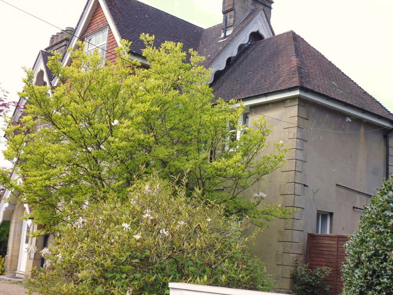
CALVERLEY PARK
1,
1746
No 3
TQ 5839 SE 7/118 20.5.52.
II* GV
2.
An early Victorian villa. This house and No 4 are built of local stone cut to
imitate bricks instead of large blocks and have a stone base and long and short
quoins.
L-shaped. 2 storeys and attics. Tiled roof with gable end to each wing and at
the south end of the east front. Each gable has scalloped bargeboards and a chimney
breast running up the centre, the north and west ones with a loop window within
the chimney and the east one a cross ornament in it. One gabled dormer. 3 casements.
Gabled porch with scalloped bargeboards.
Nos 1 to 24 (consec) form a group with Keston Lodge and Victoria Lodge.
Listing NGR: TQ5890939434
External links are from the relevant listing authority and, where applicable, Wikidata. Wikidata IDs may be related buildings as well as this specific building. If you want to add or update a link, you will need to do so by editing the Wikidata entry.


Other nearby listed buildings
