Approximate Location Map
Large Map »
Latitude: 53.8446 / 53°50'40"N
Longitude: -0.432 / 0°25'55"W
OS Eastings: 503258
OS Northings: 439845
OS Grid: TA032398
Mapcode National: GBR TRFZ.8K
Mapcode Global: WHGF4.BMJJ
Plus Code: 9C5XRHV9+R5
Entry Name: Garden Wall to No 7
Listing Date: 30 June 1987
Last Amended: 1 September 1988
Grade: II
Source: Historic England
Source ID: 1084067
English Heritage Legacy ID: 167177
ID on this website: 101084067
Location: Beverley, East Riding of Yorkshire, HU17
County: East Riding of Yorkshire
Civil Parish: Beverley
Built-Up Area: Beverley
Traditional County: Yorkshire
Lieutenancy Area (Ceremonial County): East Riding of Yorkshire
Church of England Parish: Beverley St Mary
Church of England Diocese: York
Tagged with: Wall
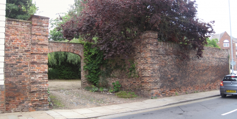
BEVERLEY HENGATE
TA Q339 (north-west side)
9/75
- Garden wall to No 7
GV II
Early C18 brick garden wall, approximately 3 metres high with 2 modern rusticated piers
and segmental carriage arch. C20 entrance to left side.
Listing NGR: TA0325839845
External links are from the relevant listing authority and, where applicable, Wikidata. Wikidata IDs may be related buildings as well as this specific building. If you want to add or update a link, you will need to do so by editing the Wikidata entry.


Other nearby listed buildings
