Approximate Location Map
Large Map »
Latitude: 51.131 / 51°7'51"N
Longitude: 0.4464 / 0°26'47"E
OS Eastings: 571269
OS Northings: 139703
OS Grid: TQ712397
Mapcode National: GBR NRJ.5MW
Mapcode Global: VHJMY.PTCV
Plus Code: 9F324CJW+9H
Entry Name: Stable Block to East of Broadford
Listing Date: 20 October 1954
Grade: II
Source: Historic England
Source ID: 1084558
English Heritage Legacy ID: 169866
ID on this website: 101084558
Location: Broad Ford, Tunbridge Wells, Kent, TN12
County: Kent
District: Tunbridge Wells
Civil Parish: Horsmonden
Traditional County: Kent
Lieutenancy Area (Ceremonial County): Kent
Church of England Parish: Horsmonden St Margaret
Church of England Diocese: Rochester
Tagged with: Stable
HORSMONDEN GOUDHURST ROAD
TQ 73 NW
(south side)
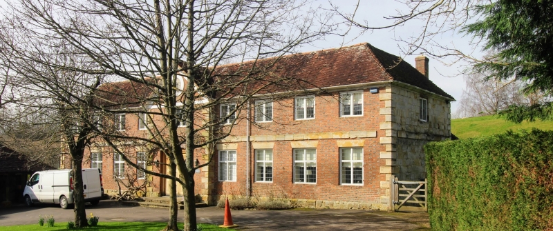
4/30 Stable block to east of
20.10.54 Broadford
GV II*
Stable block, now house. Circa 1690, converted mid and late C20. Red and blue
chequered brick and sandstone with plain tiled roof. Two storeys on sandstone
plinth with stone plat band and quoins and with moulded wooden eaves cornice to
hipped roof with stacks to rear left and rear right. Projecting centre piece with
steep pediment containing a sundial. Nine bay frontage with eight 2 light leaded
casements and centre 3 lighter, with eight leaded cross windows on ground floor
(four of which are in former stable doorways), with central glazed doors and side
lights replacing coach doors in late C20 columned porch. Rear elevations of
sandstone only with details carried across. Converted in 2 stages, the earlier
sympathetic conversion of upper floor (1947) described by C. Hussey, Country Life,
vol. CIV, 1948.
Listing NGR: TQ7130639689
External links are from the relevant listing authority and, where applicable, Wikidata. Wikidata IDs may be related buildings as well as this specific building. If you want to add or update a link, you will need to do so by editing the Wikidata entry.


Other nearby listed buildings
