Latitude: 51.0364 / 51°2'10"N
Longitude: 0.5044 / 0°30'15"E
OS Eastings: 575687
OS Northings: 129320
OS Grid: TQ756293
Mapcode National: GBR PTX.VS7
Mapcode Global: FRA C6YC.VQC
Plus Code: 9F322GP3+HQ
Entry Name: Stables, Walled Gardens and Outhouses Adjoining Collingwood House to the South and West
Listing Date: 22 June 1989
Grade: II
Source: Historic England
Source ID: 1084641
English Heritage Legacy ID: 169666
ID on this website: 101084641
Location: The Moor, Tunbridge Wells, Kent, TN18
County: Kent
District: Tunbridge Wells
Civil Parish: Hawkhurst
Built-Up Area: Hawkhurst
Traditional County: Kent
Lieutenancy Area (Ceremonial County): Kent
Tagged with: Building
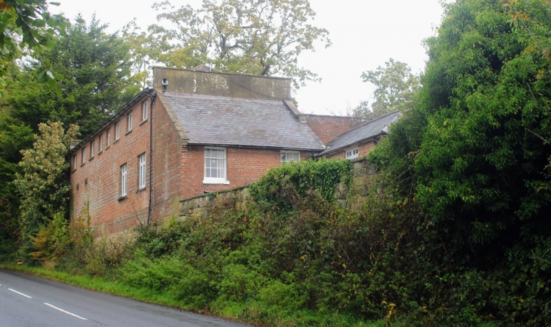
HAWKHURST HASTINGS ROAD TQ 7429-7529 (east side) 18/316 Stables, walled gardens and outhouses adjoining Collingwood House to the south and west GV II Stable block, now annexe to Bedgebury Lower School. C18. Red brick, the rear elevation in red and blue brick in band on santstone base with slate roof. Two storeys with parapet to hipped roof. Loft storey with 4 half-sized casements and blank recessed window spaces to left and to right, with C20 inserted single light to left. Four glazing bar sashes on ground floor, and boarded door to right and half-glazed door to left with sidelights, both doors with rectangular fanlights. Central carriage entrance with double carriage doors and lunette over, all in gauged semi-circular headed surround. Adjoining to the south a lean-to outhouse, 2 storeys, red and blue brick with slate roof. Two glazing bar sashes on first floor, and boarded door to right on ground floor with 2 segmentally arched open- ings to left, presumably kennels. A series of outhouses links the stable (and though later accretions, the main house) to the walled gardens, the outer court with glass house on arcaded brick base, the walls about 10 feet high of red and blue brick with sandstone wall along roadside projecting southwards from stable rear elevation about 60 yards. Inner court with walls about 10 feet high, in part buttressed, with coping, ramped at corners, and with irregular openings, enclosing an area about 20 yards by 50 yards.
Listing NGR: TQ7568729320
External links are from the relevant listing authority and, where applicable, Wikidata. Wikidata IDs may be related buildings as well as this specific building. If you want to add or update a link, you will need to do so by editing the Wikidata entry.


Other nearby listed buildings