Approximate Location Map
Large Map »
Latitude: 51.3703 / 51°22'12"N
Longitude: 1.1286 / 1°7'42"E
OS Eastings: 617858
OS Northings: 168112
OS Grid: TR178681
Mapcode National: GBR TX5.44K
Mapcode Global: VHLG2.JT0F
Plus Code: 9F3394CH+4C
Entry Name: 49-59, William Street
Listing Date: 14 May 1976
Grade: II
Source: Historic England
Source ID: 1084956
English Heritage Legacy ID: 170771
ID on this website: 101084956
Location: Herne Bay, Canterbury, Kent, CT6
County: Kent
District: Canterbury
Electoral Ward/Division: Heron
Parish: Non Civil Parish
Built-Up Area: Herne Bay
Traditional County: Kent
Lieutenancy Area (Ceremonial County): Kent
Tagged with: Building
1.
5273 WILLIAM STREET
(East Side)
Herne Bay
----------------
Nos 49 to 59 (odd)
TR 1768 SE 1/26
II GV
2.
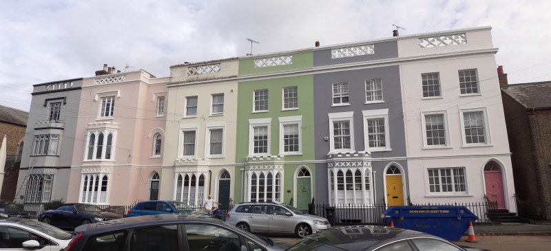
A terrace of castellated houses of about 1840. 3 storeys and basement stuccoed.
Nos 55 and 57 and the ground floor of No 51 have now been pebbledashed. No 49
has 1 window, the remainder 2 windows each. Cornice above ground moor. Cornice
and parapet, pierced with quatrefoil design above 2nd floor dripstones over 1st
and 2nd floor windows. On ground floor bays of 5 pointed lights with castellated
parapets over. Nos 49 and 51 have bays on the 1st floor as well as on the ground
floor. The 1st floor windows of Nos 51-59 are in moulded architrave surrounds,
the 2nd floor windows are plain sashes. Pointed doorcases in moulded architrave
surrounds (without porches except to No 49) with pointed fanlights and doors of
5 fielded panels.
Nos 39 to 47 (odd) North and South School Rooms,Curch of Christ Church and Nos
49 to 59 (odd) form a group.
Listing NGR: TR1785868112
External links are from the relevant listing authority and, where applicable, Wikidata. Wikidata IDs may be related buildings as well as this specific building. If you want to add or update a link, you will need to do so by editing the Wikidata entry.


Other nearby listed buildings
