Approximate Location Map
Large Map »
Latitude: 51.2773 / 51°16'38"N
Longitude: 1.078 / 1°4'40"E
OS Eastings: 614774
OS Northings: 157634
OS Grid: TR147576
Mapcode National: GBR TY2.WXT
Mapcode Global: VHLGM.M5S3
Plus Code: 9F3373GH+W6
Entry Name: 1 and 1A, Castle Street
Listing Date: 7 September 1973
Grade: II
Source: Historic England
Source ID: 1085087
English Heritage Legacy ID: 170488
ID on this website: 101085087
Location: Canterbury, Kent, CT1
County: Kent
District: Canterbury
Electoral Ward/Division: Westgate
Parish: Non Civil Parish
Built-Up Area: Canterbury
Traditional County: Kent
Lieutenancy Area (Ceremonial County): Kent
Tagged with: Building
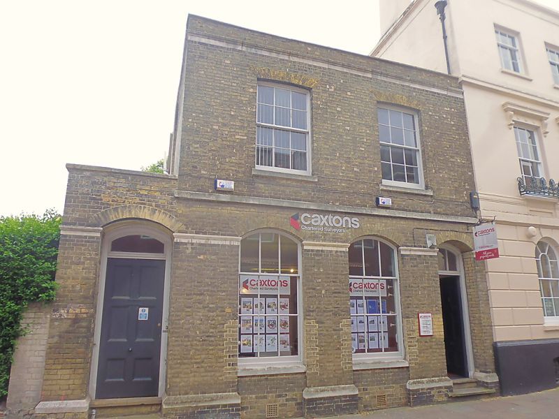
1.
944 CASTLE STREET
(South East Side)
Nos 1 & lA
TR 1457 NE 4/453
II GV
2.
Early C19. 2 storeys white brick. Parapet with stone coping. Plain moulded
cornice. 2 cambered sashes on first floor. 2 cambered sashes on ground
floor. Stringcourses. 2 cambered doorcases with fanlights.
Nos 1 to 9 (consec) and Nos 12 to 24 (consec) form a group.
Listing NGR: TR1477857629
External links are from the relevant listing authority and, where applicable, Wikidata. Wikidata IDs may be related buildings as well as this specific building. If you want to add or update a link, you will need to do so by editing the Wikidata entry.


Other nearby listed buildings
