Approximate Location Map
Large Map »
Latitude: 51.3349 / 51°20'5"N
Longitude: 1.4225 / 1°25'20"E
OS Eastings: 638494
OS Northings: 165093
OS Grid: TR384650
Mapcode National: GBR X0M.6GK
Mapcode Global: VHMCW.LQW1
Plus Code: 9F338CMC+WX
Entry Name: 10, 11 and 12, La Belle Alliance Square
Listing Date: 21 September 1984
Grade: II
Source: Historic England
Source ID: 1085343
English Heritage Legacy ID: 171875
ID on this website: 101085343
Location: Ramsgate, Thanet, Kent, CT11
County: Kent
District: Thanet
Civil Parish: Ramsgate
Built-Up Area: Ramsgate
Traditional County: Kent
Lieutenancy Area (Ceremonial County): Kent
Tagged with: Building
RAMSGATE LA BELLE
TR 3865 SW & 3865 SE
ALLIANCE SQUARE
9 & 10/243
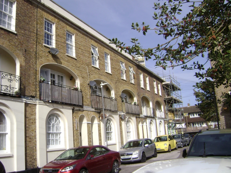
Nos. 10, 11 and 12
21.9.84
GV
II
Terrace row. Circa 1818. Stock brick, part rendered, the right return
elevation in flint. Slate roof. Three storeys and basement on plinth
with cill band, moulded cornice and parapet. Two glazing bar sashes to
each house unit on 2nd floor (6 bays in all). Two French windows on
1st floor in moulded surrounds, set within gauged elliptical recessed
verandah with C20 railings to all 3 houses. Projecting and rendered
ground floor window surrounds with recessed round headed margin light
glazing bar sashes to Nos. 10 and 12, sash to No. 11. Projecting brick
doorways to left and paired to centre right, with boarded doors and semi-
circular fanlights. Basement openings below windows. Originally joined
to Nos. 4, 5 and 6 (item 9/244 ), now with C20 houses between rebuilt
in same style.
Listing NGR: TR3849465093
External links are from the relevant listing authority and, where applicable, Wikidata. Wikidata IDs may be related buildings as well as this specific building. If you want to add or update a link, you will need to do so by editing the Wikidata entry.


Other nearby listed buildings
