Approximate Location Map
Large Map »
Latitude: 51.3355 / 51°20'7"N
Longitude: 1.4155 / 1°24'55"E
OS Eastings: 638006
OS Northings: 165141
OS Grid: TR380651
Mapcode National: GBR X0L.BNX
Mapcode Global: VHMCW.HP6K
Plus Code: 9F338CP8+66
Entry Name: Chapel Cottage
Listing Date: 4 February 1988
Grade: II
Source: Historic England
Source ID: 1085397
English Heritage Legacy ID: 171718
ID on this website: 101085397
Location: Ramsgate, Thanet, Kent, CT11
County: Kent
District: Thanet
Civil Parish: Ramsgate
Built-Up Area: Ramsgate
Traditional County: Kent
Lieutenancy Area (Ceremonial County): Kent
Tagged with: Cottage
RAMSGATE CHAPEL PLACE LANE
TR 3865 SW
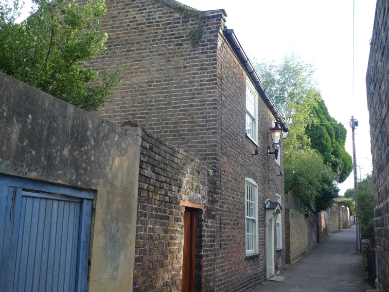
9/89 Chapel Cottage
GV II
House. 1830's. Stock brick and slate roof. Two storeys, with kneelered
parapet gables and stacks to left and to right. Regular fenestration of
2 glazing bar sashes on each floor, with cambered heads on ground floor.
Central boarded door with gabled hood on brackets.
Listing NGR: TR3800665141
External links are from the relevant listing authority and, where applicable, Wikidata. Wikidata IDs may be related buildings as well as this specific building. If you want to add or update a link, you will need to do so by editing the Wikidata entry.


Other nearby listed buildings
