Approximate Location Map
Large Map »
Latitude: 51.2409 / 51°14'27"N
Longitude: 0.6028 / 0°36'9"E
OS Eastings: 581775
OS Northings: 152297
OS Grid: TQ817522
Mapcode National: GBR QT1.37C
Mapcode Global: VHJMN.D2JK
Plus Code: 9F326JR3+94
Entry Name: Burnt Barn Farm House
Listing Date: 26 April 1968
Grade: II
Source: Historic England
Source ID: 1086138
English Heritage Legacy ID: 173851
ID on this website: 101086138
Location: Leeds, Maidstone, Kent, ME17
County: Kent
District: Maidstone
Civil Parish: Leeds
Traditional County: Kent
Lieutenancy Area (Ceremonial County): Kent
Tagged with: Farmhouse
LEEDS UPPER STREET
TQ 85 SW (west side)
3/117 Burnt Barn Farm house
26.4.68.
II
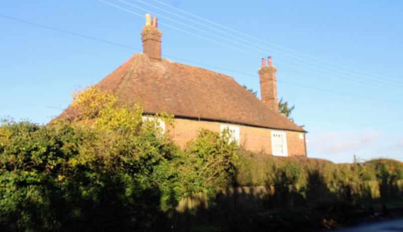
Farmhouse. Mid C16 with later C18 facade. Timber framed, clad
in red brick in Flemish bond, first floor of left end tile-hung.
Plain tile roof. 4 timber-framed bays with jetty to front and
both ends. 2 storeys on brick plinth with slightly coved eaves
cornice and hipped roof. Red brick ridge stack towards left
end and red brick stack at right end. Irregular fenestration
of 3 glazing-bar sashes. Ground floor windows with segmental
heads. Panelled door with 2 top lights to right of centre,
between centre and right end windows. C19 rear lean-to. Interior:
central ground-floor room has moulded end and cross-beams, hollow-
chamfered joists and moulded four-centred arched stone fireplace.
Clean, moulded crown-post. West side continued on Page 61.
Listing NGR: TQ8177252300
External links are from the relevant listing authority and, where applicable, Wikidata. Wikidata IDs may be related buildings as well as this specific building. If you want to add or update a link, you will need to do so by editing the Wikidata entry.


Other nearby listed buildings
