Approximate Location Map
Large Map »
Latitude: 51.2407 / 51°14'26"N
Longitude: 0.6805 / 0°40'49"E
OS Eastings: 587202
OS Northings: 152466
OS Grid: TQ872524
Mapcode National: GBR QT4.4W5
Mapcode Global: VHJMP.R23R
Plus Code: 9F326MRJ+76
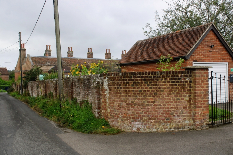
Entry Name: Garden Wall in 2 Sections Enclosing Approximately 1 Acre of Land Immediately to Rear of Almshouses
Listing Date: 14 December 1984
Grade: II
Source: Historic England
Source ID: 1086142
English Heritage Legacy ID: 173759
ID on this website: 101086142
Location: Harrietsham, Maidstone, Kent, ME17
County: Kent
District: Maidstone
Civil Parish: Harrietsham
Built-Up Area: Harrietsham
Traditional County: Kent
Lieutenancy Area (Ceremonial County): Kent
Tagged with: Wall
HARRIETSHAM EAST STREET
TQ 85 SE (north east side)
4/26 Garden wall in 2
sections enclosing
approx. 1 acre of
land immediately to
rear of Almshouses
GV II
Garden wall. 1770's. Red brick in Flemish bond with plain up-
ended brick coping. About 6' high, ramped up to about 8'
in north-east corner. Shallow brick buttresses inside and out
at about 8' intervals. South-east length interrupted by C20
brick gate piers about 20 yards from north east corner, and by
plan 1770's gate-piers about 60 yards from same corner. Listed
for group value.
Listing NGR: TQ8714252418
External links are from the relevant listing authority and, where applicable, Wikidata. Wikidata IDs may be related buildings as well as this specific building. If you want to add or update a link, you will need to do so by editing the Wikidata entry.


Other nearby listed buildings
