Approximate Location Map
Large Map »
Latitude: 51.3874 / 51°23'14"N
Longitude: 0.5047 / 0°30'16"E
OS Eastings: 574372
OS Northings: 168346
OS Grid: TQ743683
Mapcode National: GBR PPN.VTK
Mapcode Global: VHJLT.PDN9
Plus Code: 9F329GP3+WV
Entry Name: Rochester City Walls
Listing Date: 24 October 1950
Last Amended: 2 December 1991
Grade: I
Source: Historic England
Source ID: 1086506
English Heritage Legacy ID: 172928
ID on this website: 101086506
Location: Rochester, Medway, Kent, ME1
County: Medway
Electoral Ward/Division: Rochester West
Parish: Non Civil Parish
Built-Up Area: Rochester
Traditional County: Kent
Lieutenancy Area (Ceremonial County): Kent
Church of England Parish: Rochester St Peter Parish Centre
Church of England Diocese: Rochester
Tagged with: City walls
ROCHESTER
TQ 7468 NW TQ 7468 SW
7/2A and 9/2B,C,D Rochester City
Walls
(formerly listed
as The Town Walls)
24.10.50
GV I
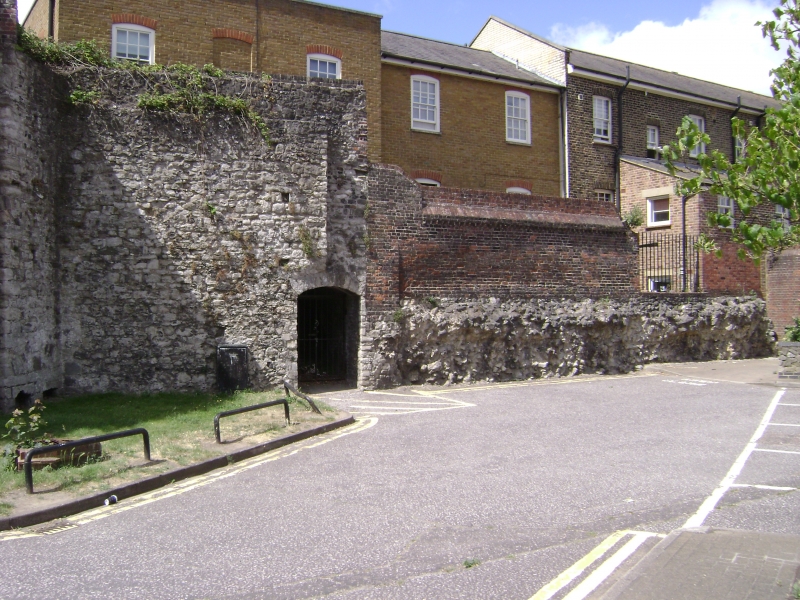
City walls. Mainly C13 and C14, incorporating Roman remains,
with later patching and partial rebuilding. The 4 surviving
stretches are distinguished on the map as 7/2A (off The Common),
9/2B (off Free School Lane), 9/2C (enclosing City Ditch) and 9/2D
(off St Margaret's Street. None have post office addresses.
7/2A runs N/S for about 30 metres and is in a fragmentary state
with little facing stone surviving, some parts underpinning later
structures. 9/2B is the most impressive and upstanding section
incorporating the NE circular bastion (of 2 storeys with 3
lancets to upper stage). The upper courses of the wall attached
are largely rebuilt; a short stretch retains coped merlons.
9/2C, rebuilt when the city walls were pushed further out in the
Mid C14 retains the SE bastion, much reduced. 9/2D is short and
much renewed. Scheduled Ancient Monument.
Listing NGR: TQ7427568816
External links are from the relevant listing authority and, where applicable, Wikidata. Wikidata IDs may be related buildings as well as this specific building. If you want to add or update a link, you will need to do so by editing the Wikidata entry.


Other nearby listed buildings
