Approximate Location Map
Large Map »
Latitude: 54.362 / 54°21'43"N
Longitude: -2.5914 / 2°35'29"W
OS Eastings: 361664
OS Northings: 496434
OS Grid: SD616964
Mapcode National: GBR BLB0.R3
Mapcode Global: WH93X.5M7D
Plus Code: 9C6V9C65+QC
Entry Name: Lowgill Viaduct
Listing Date: 21 February 1989
Grade: II
Source: Historic England
Source ID: 1086909
English Heritage Legacy ID: 75637
ID on this website: 101086909
Location: Lowgill, Westmorland and Furness, Cumbria, LA8
County: Cumbria
District: South Lakeland
Civil Parish: Firbank
Traditional County: Westmorland
Lieutenancy Area (Ceremonial County): Cumbria
Church of England Parish: Firbank, Howgill and Killington
Church of England Diocese: Carlisle
Tagged with: Railway viaduct
SD 69 NW
8/58
FIRBANK
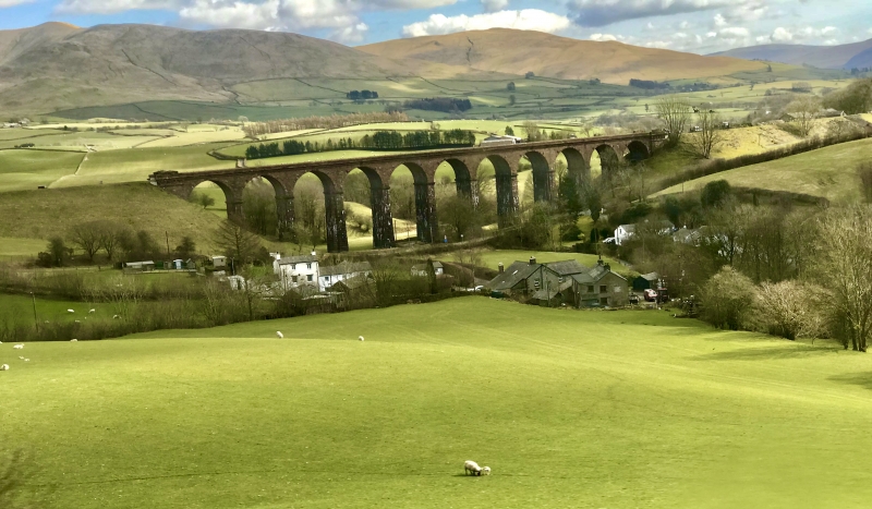
Lowgill Viaduct
G.V.
II
Railway viaduct. 1859 by Joseph Locke and John Errington. For Ingleton branch
of the London and North Western Railway. Rock-faced sandstone. 11 round arches
on slightly battered piers with impost bands; cornice and blocking course. End
piers have dentilled cornices and triangular-headed caps.
Listing NGR: SD6166496434
External links are from the relevant listing authority and, where applicable, Wikidata. Wikidata IDs may be related buildings as well as this specific building. If you want to add or update a link, you will need to do so by editing the Wikidata entry.


Other nearby listed buildings
