Approximate Location Map
Large Map »
Latitude: 53.1409 / 53°8'27"N
Longitude: -1.809 / 1°48'32"W
OS Eastings: 412873
OS Northings: 360428
OS Grid: SK128604
Mapcode National: GBR 477.5FP
Mapcode Global: WHCDK.5BT0
Plus Code: 9C5W45RR+8C
Entry Name: R Stones - General Stores
Listing Date: 10 August 1951
Last Amended: 27 July 1984
Grade: II
Source: Historic England
Source ID: 1087852
English Heritage Legacy ID: 80557
ID on this website: 101087852
Location: Hartington, Derbyshire Dales, Derbyshire, SK17
County: Derbyshire
District: Derbyshire Dales
Civil Parish: Hartington Town Quarter
Traditional County: Derbyshire
Lieutenancy Area (Ceremonial County): Derbyshire
Church of England Parish: Hartington St Giles
Church of England Diocese: Derby
Tagged with: Building
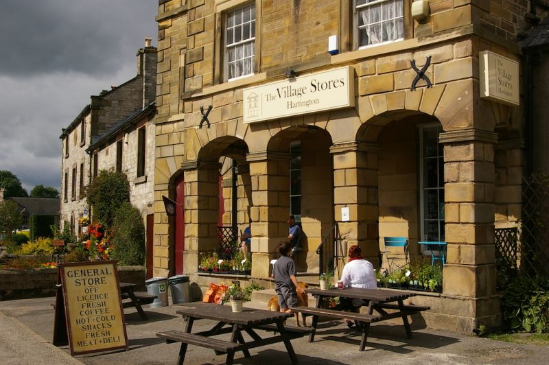
SK 12 60 PARISH OF HARTINGTON TOWN QUARTER MARKET PLACE
12/127 (North Side)
10.8.1951 R Stones - General Stores
(formerly listed as
'Co-operative Stores',
formerly Market-Hall)
GV II
Market hall, now shop. 1836. Coursed squared sandstone with diagonal- and
horizontal tooling. Sandstone dressings, rusticated ashlar quoins and ground
floor. Slate roof. Stone gable end stacks with plain cornices. Stone coped
gables. Moulded eaves cornice and pedimented gable. Three storeys, three bays,
advanced two bay section to east. South elevation - three steps to raised arcade
of three segmental arches with moulded imposts on square rusticated piers. Similar
arches to north and south sides. To west, recessed section with centrally placed
segmentally headed archway with double plank doors below. Above plain
sillband Three glazing bar sashes with moulded architraves over. Similar,
but shallower, window with plain sill band- to third storey. Above, in
eastern gable pediment, a large plaque, decorated by central figure of man in short
coat holding scales with a woman either side and inscribed: 'JH MDCCCXXXVI'.
Listing NGR: SK1287360428
External links are from the relevant listing authority and, where applicable, Wikidata. Wikidata IDs may be related buildings as well as this specific building. If you want to add or update a link, you will need to do so by editing the Wikidata entry.


Other nearby listed buildings
