Approximate Location Map
Large Map »
Latitude: 52.9108 / 52°54'38"N
Longitude: -1.2831 / 1°16'59"W
OS Eastings: 448309
OS Northings: 335056
OS Grid: SK483350
Mapcode National: GBR 7GN.DFV
Mapcode Global: WHDH3.838C
Plus Code: 9C4WWP68+8Q
Entry Name: Canal Bridge at SK 484 351
Listing Date: 2 May 1986
Grade: II
Source: Historic England
Source ID: 1087968
English Heritage Legacy ID: 82204
ID on this website: 101087968
Location: Erewash, Derbyshire, NG10
County: Derbyshire
District: Erewash
Electoral Ward/Division: Derby Road East
Parish: Non Civil Parish
Built-Up Area: Long Eaton
Traditional County: Derbyshire
Lieutenancy Area (Ceremonial County): Derbyshire
Church of England Parish: Sandiacre St Giles
Church of England Diocese: Derby
Tagged with: Bridge
PARISH OF LONG EATON BENNETT STREET
SK 48 NE
2/17 (East Side)
Canal Bridge at
SK 484 351
GV II
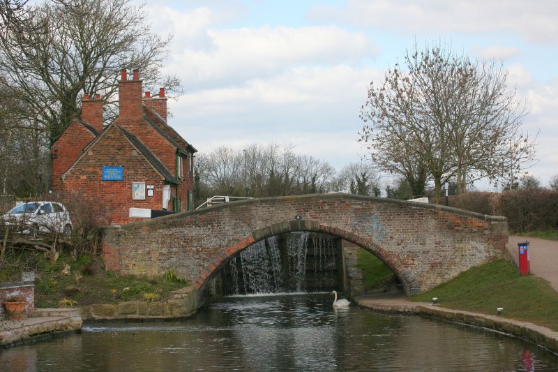
Canal bridge. 1779, by engineer John Varley, partly rebuilt in
C20. Red brick with stone copings. Single segmental arch with
plain brick spandrels and stone copings to parapets. Walls
splay outwards and end in plain brick piers. Built as part of
the Erewash Canal. Included for group value only.
Listing NGR: SK4830935056
External links are from the relevant listing authority and, where applicable, Wikidata. Wikidata IDs may be related buildings as well as this specific building. If you want to add or update a link, you will need to do so by editing the Wikidata entry.


Other nearby listed buildings
