Approximate Location Map
Large Map »
Latitude: 51.988 / 51°59'16"N
Longitude: -1.7022 / 1°42'7"W
OS Eastings: 420548
OS Northings: 232211
OS Grid: SP205322
Mapcode National: GBR 4PB.8H0
Mapcode Global: VHBYZ.F9ZC
Plus Code: 9C3WX7QX+54
Entry Name: The Old Parsonage
Listing Date: 30 June 1983
Grade: II
Source: Historic England
Source ID: 1088676
English Heritage Legacy ID: 126642
ID on this website: 101088676
Location: Moreton-in-Marsh, Cotswold, Gloucestershire, GL56
County: Gloucestershire
District: Cotswold
Civil Parish: Moreton-in-Marsh
Built-Up Area: Moreton-in-Marsh
Traditional County: Gloucestershire
Lieutenancy Area (Ceremonial County): Gloucestershire
Church of England Parish: Moreton-in-Marsh St David
Church of England Diocese: Gloucester
Tagged with: Clergy house
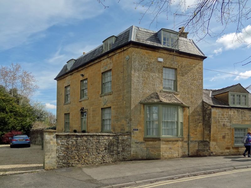
1.
5224 MORETON-IN-THE-MARSH CHURCH STREET
(north side)
The Old Parsonage
SP 2032 SE 2/80
II GV
2.
Early C19. Ashlar with first floor string. Two storeys and attic, 2 windows,
16 pane sashes, false central window on upper floor. Central 6 panel door with
fanlight and stone architrave. Slate mansard with 2 elliptically headed dormers.
One window front to street with canted bay on ground floor. Rear: roughly v-plan
to the wings with hipped mansards, south wing with chimney, north wing with one
range of Gothic windows with intersecting glazing bars.
Listing NGR: SP2054832211
External links are from the relevant listing authority and, where applicable, Wikidata. Wikidata IDs may be related buildings as well as this specific building. If you want to add or update a link, you will need to do so by editing the Wikidata entry.


Other nearby listed buildings
