Approximate Location Map
Large Map »
Latitude: 51.6357 / 51°38'8"N
Longitude: -2.1579 / 2°9'28"W
OS Eastings: 389167
OS Northings: 192995
OS Grid: ST891929
Mapcode National: GBR 1P0.F7R
Mapcode Global: VH95K.K41Y
Plus Code: 9C3VJRPR+7R
Entry Name: 19, the Green
Listing Date: 6 September 1954
Grade: II
Source: Historic England
Source ID: 1089647
English Heritage Legacy ID: 128493
ID on this website: 101089647
Location: Tetbury, Cotswold, Gloucestershire, GL8
County: Gloucestershire
District: Cotswold
Civil Parish: Tetbury
Built-Up Area: Tetbury
Traditional County: Gloucestershire
Lieutenancy Area (Ceremonial County): Gloucestershire
Church of England Parish: Tetbury St Mary the Virgin
Church of England Diocese: Gloucester
Tagged with: Building
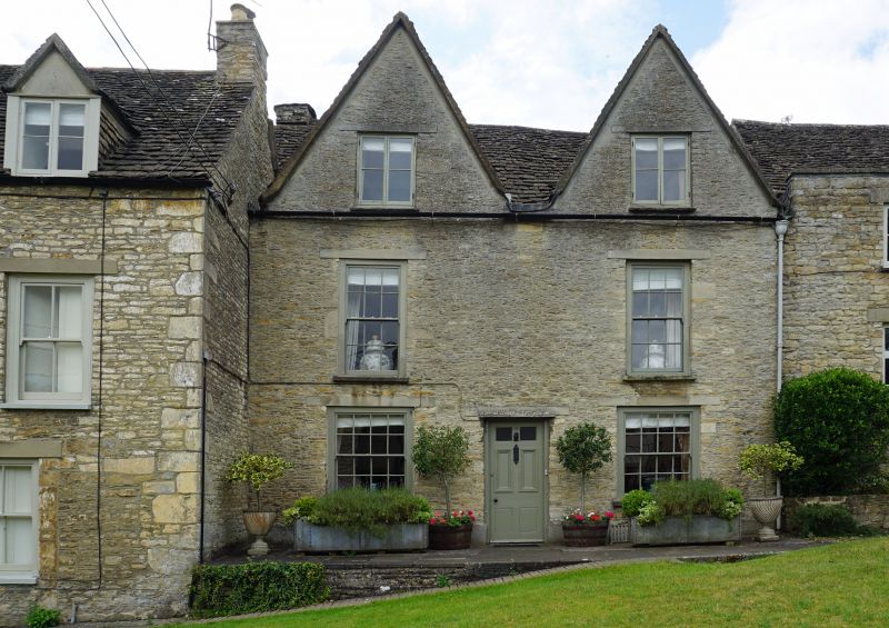
ST 8893-8993 TETBURY THE GREEN
ST 8892-8992 (south side)
7/219 and 8/219 No 19
6.9.54
GV II
House in terrace. Late C17/early C18. Rubble stone with Cotswold
stone slate roof, truncated stone gable stack to left. Single
range and rear extension, with 2 steep cross gables. 2 storeys and
attic. 2 windows, long 12-pane sashes shallow set with concrete
lintels. Ground floor has wider 16-pane sashes and central door
with 2 glazed, 2 bolection and 2 flush panels. Each gable has twin
C19 wood casements.
Listing NGR: ST8916792995
External links are from the relevant listing authority and, where applicable, Wikidata. Wikidata IDs may be related buildings as well as this specific building. If you want to add or update a link, you will need to do so by editing the Wikidata entry.


Other nearby listed buildings
