Approximate Location Map
Large Map »
Latitude: 51.8812 / 51°52'52"N
Longitude: -1.6733 / 1°40'23"W
OS Eastings: 422585
OS Northings: 220341
OS Grid: SP225203
Mapcode National: GBR 5S1.3R4
Mapcode Global: VHBZC.YZ88
Plus Code: 9C3WV8JG+FM
Entry Name: Manor Farmhouse and Front Boundary Wall
Listing Date: 28 May 1987
Grade: II
Source: Historic England
Source ID: 1090258
English Heritage Legacy ID: 130996
ID on this website: 101090258
Location: Nether Westcote, Cotswold, Gloucestershire, OX7
County: Gloucestershire
District: Cotswold
Civil Parish: Westcote
Traditional County: Gloucestershire
Lieutenancy Area (Ceremonial County): Gloucestershire
Church of England Parish: Westcote St Mary the Virgin
Church of England Diocese: Gloucester
Tagged with: Farmhouse
WESTCOTE NETHER WESTCOTE
SP 22 SW
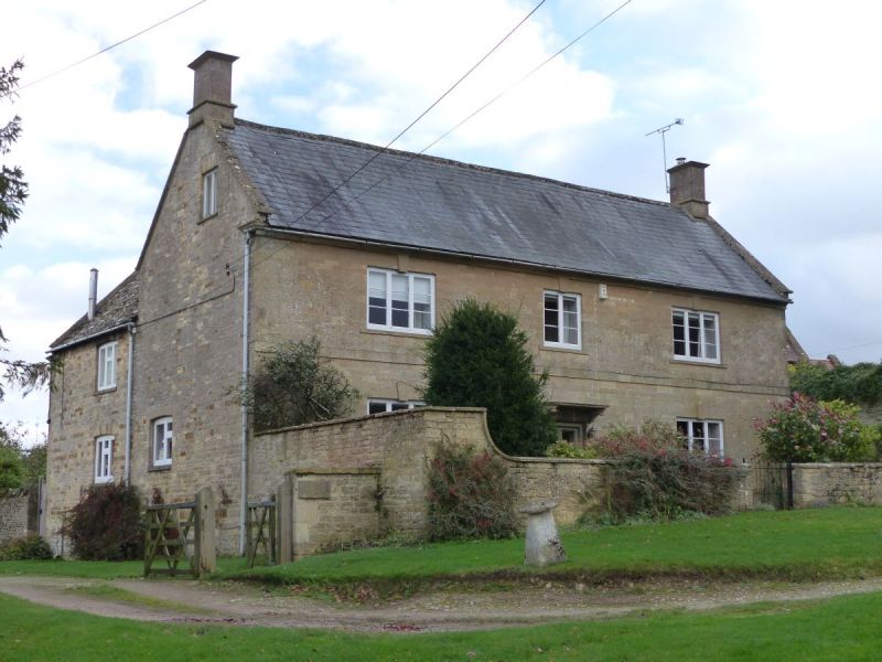
2/265 Manor Farmhouse and
front boundary wall
GV II
Detached house. C18 with C19 extensions at rear. Ashlar facade,
otherwise coursed squared and dressed limestone and brick. Grey
slate at front, some concrete tile and stone slate at rear.
Rendered stacks. Rectangular main body with two C19 extensions at
right angles at rear with linking brick lean-to. Two storeys and
attic; symmetrical 3-windowed facade lit by two and 3-light C20
wooden casements with keystones. Two-light attic windows in gable
ends. Band between floors, moulded eaves cornice. Central 6-panel
door with glass in the former panels and flat canopy with moulded
margin on moulded stone brackets. Flat coped gables. Gable-end
stacks with moulded cappings and flat-chamfered skirtings.
Interior not inspected.
Wall across front of house. Coursed squared and dressed limestone
with flat coping. The wall runs across the front of the house then
returns back to its corners 1-1.70m in height where it is ramped up
at either end.
Listing NGR: SP2258520341
External links are from the relevant listing authority and, where applicable, Wikidata. Wikidata IDs may be related buildings as well as this specific building. If you want to add or update a link, you will need to do so by editing the Wikidata entry.


Other nearby listed buildings
