Approximate Location Map
Large Map »
Latitude: 51.7053 / 51°42'19"N
Longitude: -2.1856 / 2°11'8"W
OS Eastings: 387270
OS Northings: 200746
OS Grid: SO872007
Mapcode National: GBR 1N6.07W
Mapcode Global: VH955.2DDK
Plus Code: 9C3VPR47+4Q
Entry Name: Ram Inn
Listing Date: 24 March 1988
Grade: II
Source: Historic England
Source ID: 1091073
English Heritage Legacy ID: 133073
ID on this website: 101091073
Location: Minchinhampton, Stroud, Gloucestershire, GL6
County: Gloucestershire
District: Stroud
Civil Parish: Minchinhampton
Built-Up Area: Minchinhampton
Traditional County: Gloucestershire
Lieutenancy Area (Ceremonial County): Gloucestershire
Church of England Parish: Minchinhampton with Box
Church of England Diocese: Gloucester
Tagged with: Inn
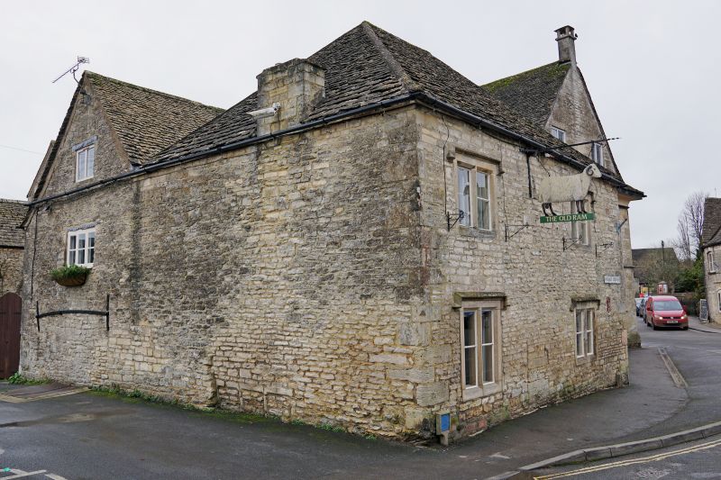
SO 8600-8700 MINCHINHAMPTON MARKET SQUARE, Minchinhampton Town
(south side)
19/281 Ram Inn
GV II
Inn. Late C17, altered mid-late C18. Random rubble limestone,
part in red brick; ashlar and brick chimneys; stone slate roof.
Two-storey rectangular block with 2-storey addition on north west
side; outbuildings form courtyard to south west. North east side:
2-window fenestration, probably originally below 2 gables. Three
original chamfered mullioned 2-light casements; 6-pane sash
replacement to ground floor. C18 hipped roof. Return elevation to
right includes 2 casements in openings with moulded architraves and
flat dripstone above. Lower brick-built hipped roofed addition has
mainly C20 casements. South east side: one full gable with
blocked attic window. Low level blocked 3-light casement partially
obscured by raising of road level. Eaves-mounted chimney above
with plain cap. Interior not inspected. Recorded as an inn since
1718. Important position next to Market House (q.v.).
Listing NGR: SO8726300742
External links are from the relevant listing authority and, where applicable, Wikidata. Wikidata IDs may be related buildings as well as this specific building. If you want to add or update a link, you will need to do so by editing the Wikidata entry.


Other nearby listed buildings
