Latitude: 50.9217 / 50°55'18"N
Longitude: -1.475 / 1°28'29"W
OS Eastings: 436999
OS Northings: 113714
OS Grid: SU369137
Mapcode National: GBR 767.5X6
Mapcode Global: FRA 76SN.Z1P
Plus Code: 9C2WWGCG+M2
Entry Name: Redbridge Bridge
Listing Date: 8 October 1981
Grade: II*
Source: Historic England
Source ID: 1091972
English Heritage Legacy ID: 135935
ID on this website: 101091972
Location: Redbridge, Southampton, Hampshire, SO40
County: City of Southampton
Electoral Ward/Division: Redbridge
Parish: Non Civil Parish
Built-Up Area: Southampton
Traditional County: Hampshire
Lieutenancy Area (Ceremonial County): Hampshire
Church of England Parish: Maybush
Church of England Diocese: Winchester
Tagged with: Bridge
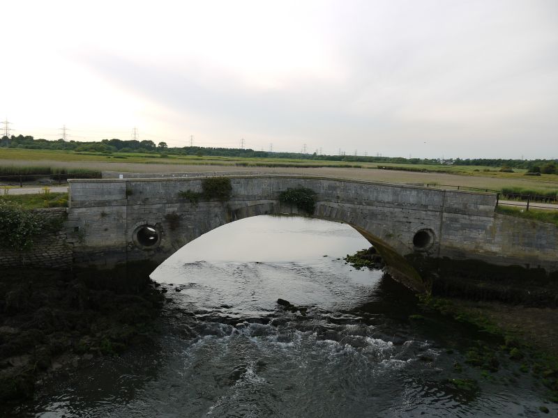
1. TEST LANE
5239 Redbridge
Redbridge Bridge
SU 31 SE 9/239
II*
2.
C17 but on the site of an earlier bridge and of mediaeval type. Built of
rubble and ashlar. Five arches with semi-circular arches having double archings.
Cut waters on downstream side. Solid parapet.
Listing NGR: SU3699913714
External links are from the relevant listing authority and, where applicable, Wikidata. Wikidata IDs may be related buildings as well as this specific building. If you want to add or update a link, you will need to do so by editing the Wikidata entry.


Other nearby listed buildings