Latitude: 50.8976 / 50°53'51"N
Longitude: -1.3978 / 1°23'52"W
OS Eastings: 442444
OS Northings: 111080
OS Grid: SU424110
Mapcode National: GBR RRL.0N
Mapcode Global: FRA 76YQ.R8K
Plus Code: 9C2WVJX2+3V
Entry Name: 30, Queen's Terrace
Listing Date: 14 February 1969
Grade: II
Source: Historic England
Source ID: 1092002
English Heritage Legacy ID: 135903
ID on this website: 101092002
Location: Ocean Village, Southampton, Hampshire, SO14
County: City of Southampton
Electoral Ward/Division: Bargate
Parish: Non Civil Parish
Built-Up Area: Southampton
Traditional County: Hampshire
Lieutenancy Area (Ceremonial County): Hampshire
Church of England Parish: Southampton City Centre St Mary
Church of England Diocese: Winchester
Tagged with: Building
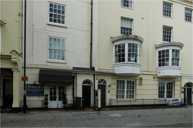
1. QUEEN'S TERRACE
5239
SU 4211 4/210 14.2.69 No 30
II
2.
Early C19. Four storeys stuccoed with rusticated ground floor. Cornice flanked
by first to third floor. Ionic pilasters. One sash to all floors with glazing
bars intact. Round-headed doorcase.
Listing NGR: SU4244411080
External links are from the relevant listing authority and, where applicable, Wikidata. Wikidata IDs may be related buildings as well as this specific building. If you want to add or update a link, you will need to do so by editing the Wikidata entry.


Other nearby listed buildings