Approximate Location Map
Large Map »
Latitude: 51.2861 / 51°17'9"N
Longitude: -0.956 / 0°57'21"W
OS Eastings: 472902
OS Northings: 154622
OS Grid: SU729546
Mapcode National: GBR C7S.C3X
Mapcode Global: VHDXL.CXYZ
Plus Code: 9C3X72PV+CH
Entry Name: Lees Farm Cottage
Listing Date: 26 June 1987
Grade: II
Source: Historic England
Source ID: 1092226
English Heritage Legacy ID: 136809
ID on this website: 101092226
Location: Holt, Hart, Hampshire, RG27
County: Hampshire
District: Hart
Civil Parish: Hook
Built-Up Area: Hook
Traditional County: Hampshire
Lieutenancy Area (Ceremonial County): Hampshire
Church of England Parish: Hook
Church of England Diocese: Winchester
Tagged with: Cottage
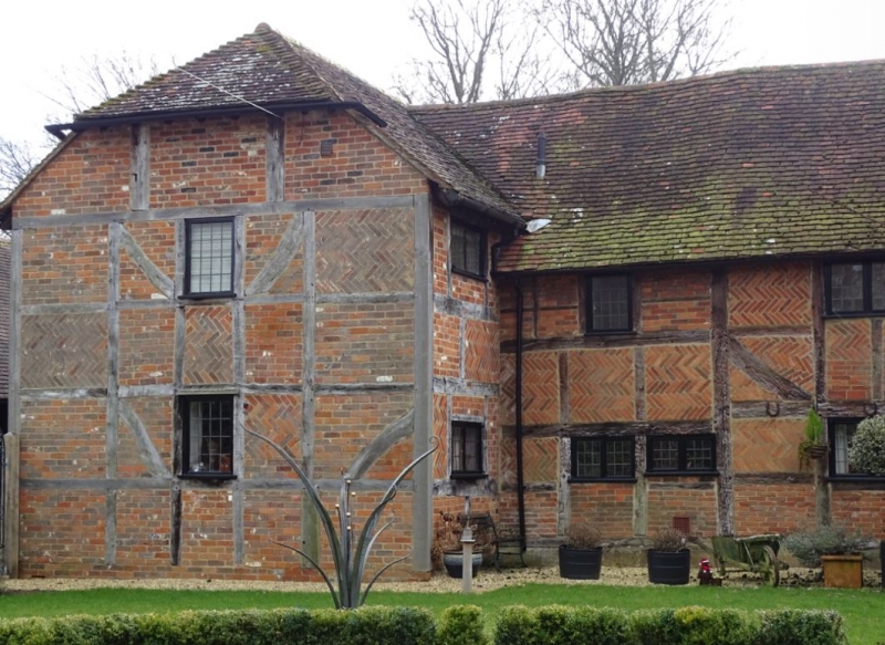
SU 75 SW HOOK LONDON ROAD
8/9 Lees Farm Cottage
-
- II
C17 and modern. 2 storeyed long timber-framed farmhouse with irregular
fenestration, and a modern wing at the east end (in matching style). Red
tile roof, 1/2-hipped. Exposed framing has red herring-bone brick infilling.
Modern casements and doorway.
Listing NGR: SP7515453771
External links are from the relevant listing authority and, where applicable, Wikidata. Wikidata IDs may be related buildings as well as this specific building. If you want to add or update a link, you will need to do so by editing the Wikidata entry.


Other nearby listed buildings
