Approximate Location Map
Large Map »
Latitude: 51.3618 / 51°21'42"N
Longitude: -1.2094 / 1°12'34"W
OS Eastings: 455137
OS Northings: 162823
OS Grid: SU551628
Mapcode National: GBR 93V.F22
Mapcode Global: VHCZS.Z1GC
Plus Code: 9C3W9Q6R+P6
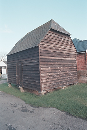
Entry Name: Granary 10 Yards East of Woodhouse Farmhouse
Listing Date: 18 May 1984
Grade: II
Source: Historic England
Source ID: 1092466
English Heritage Legacy ID: 138272
ID on this website: 101092466
Location: Hyde End, Basingstoke and Deane, Hampshire, RG19
County: Hampshire
District: Basingstoke and Deane
Civil Parish: Ashford Hill with Headley
Traditional County: Hampshire
Lieutenancy Area (Ceremonial County): Hampshire
Church of England Parish: Ashford Hill with Headley
Church of England Diocese: Winchester
Tagged with: Granary
SU 56 SE KINGSCLERE WOODHOUSE LANE
4/2
Granary 10 yds east
of Woodhouse Farmhouse
II
Early C19. Timber-frame on 9 staddles. Half-hipped slate roof. Boarded walls.
External links are from the relevant listing authority and, where applicable, Wikidata. Wikidata IDs may be related buildings as well as this specific building. If you want to add or update a link, you will need to do so by editing the Wikidata entry.


Other nearby listed buildings
