Approximate Location Map
Large Map »
Latitude: 50.9705 / 50°58'13"N
Longitude: -1.7839 / 1°47'1"W
OS Eastings: 415270
OS Northings: 119029
OS Grid: SU152190
Mapcode National: GBR 52L.5SL
Mapcode Global: FRA 764K.4TC
Plus Code: 9C2WX6C8+5C
Entry Name: Breamore House
Listing Date: 25 February 1958
Last Amended: 13 February 1987
Grade: II*
Source: Historic England
Source ID: 1094935
English Heritage Legacy ID: 143830
Also known as: Breamore
ID on this website: 101094935
Location: North Street, New Forest, Hampshire, SP6
County: Hampshire
District: New Forest
Civil Parish: Breamore
Traditional County: Hampshire
Lieutenancy Area (Ceremonial County): Hampshire
Church of England Parish: Breamore St Mary
Church of England Diocese: Winchester
Tagged with: Historic house museum English country house Country house
SU 11 NE BREAMORE BREAMORE PARK
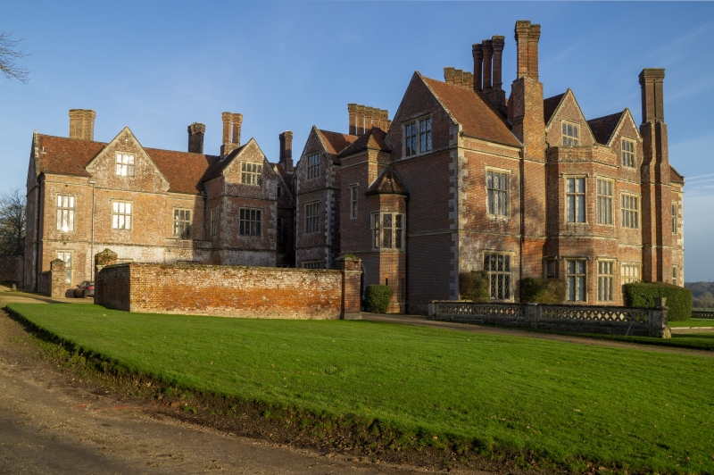
6/2 Breamore House
25.2.58 (Formerly listed as
GV Breamore House with Stabling)
II*
Mansion. 1583, with minor C18 changes: following a fire of 1856, there
was considerable restoration, in style. Walls of brickwork in English
bond with stone dressings; plinth, flush quoins, mullion and transom
windows beneath hood moulds, weathered bands to 1st and 2nd floors, coved
eaves and gables. Tile roof, Tudor stacks with diagonal flues on
rectangular bases. Large L-shaped block, with symmetrical E-shaped east
front, of two storeys and attic, 1.3.1.3.1 windows (five gables).
Windows of six and eight lights (mostly of the restoration date). C18
doorcase, with cornice on console brackets, pulvinated frieze, eared
architraves; this is approached by an entrance raised on six steps (at
each side) with a pierced balustrade capped by two urns. Within the
angle, each facade has a central projecting unit, and at each outer
corner there is a staircase turret; the forecourt has an outer brick wall
with gateway piers. The other outer (north-east) range is less regular,
without projections, four gables, attached stacks, and single-storeyed
wings. A paved area to the east front has a stone balustrade with
diaper piercings.
Listing NGR: SU1526519048
External links are from the relevant listing authority and, where applicable, Wikidata. Wikidata IDs may be related buildings as well as this specific building. If you want to add or update a link, you will need to do so by editing the Wikidata entry.


Other nearby listed buildings
