Latitude: 51.0905 / 51°5'25"N
Longitude: -1.1589 / 1°9'31"W
OS Eastings: 459003
OS Northings: 132690
OS Grid: SU590326
Mapcode National: GBR 976.FV6
Mapcode Global: FRA 86G7.NB0
Plus Code: 9C3W3RRR+5C
Entry Name: Cardew House
Listing Date: 5 December 1955
Last Amended: 16 November 1983
Grade: II
Source: Historic England
Source ID: 1095223
English Heritage Legacy ID: 145094
ID on this website: 101095223
Location: New Alresford, Winchester, Hampshire, SO24
County: Hampshire
District: Winchester
Civil Parish: New Alresford
Built-Up Area: New Alresford
Traditional County: Hampshire
Lieutenancy Area (Ceremonial County): Hampshire
Church of England Parish: New Alresford St John the Baptist
Church of England Diocese: Winchester
Tagged with: House
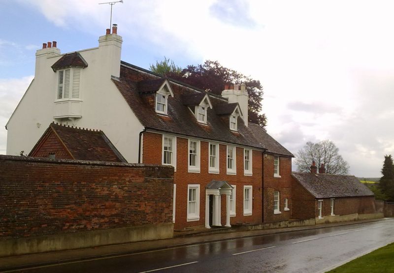
SU 53 SE NEW ALRESFORD EAST STREET
(North Side)
8/57 No 29
(Cardew House) (formerly
5.12.55 listed as Cardew Hotel)
GV II
Large house. Mid C18, early and late C19. Brick and tile. Symmetrical front
(south) of 2 storeys and attic, 5 windows, with a wide addition at the east
side (of the middle date) of 1 window. Walling of red brickwork in Flemish
bond (with blue headers to the later wing) cement plain architraves, stone
cills. Victorian sashes (sashes of the early C19 at the east wing): 3 gabled
dormers with bargeboards and sashs. Doric porch with open pediment and panelled
soffit, 2 pilasters and 2 columns, with fluted necking, wide-arched-opening
with radiating fanlight, 6-panelled door. The original double-pile roof has
been replaced with a flat centre, overlapping with a tile-hung vertical at the
top of the front slope, with sash windows (the west an oriel) in the end gables,
which are flanked by chimneys. The house has a shallow forecourt, the east side
stopped by a single-storeyed service wing (i.e. up to the highway) of brick and
tile, and the west side by a high brick boundary wall (Flemish Garden Wall bond)
on a plinth.
Listing NGR: SU5901032690
External links are from the relevant listing authority and, where applicable, Wikidata. Wikidata IDs may be related buildings as well as this specific building. If you want to add or update a link, you will need to do so by editing the Wikidata entry.


Other nearby listed buildings