Approximate Location Map
Large Map »
Latitude: 53.3598 / 53°21'35"N
Longitude: -1.8027 / 1°48'9"W
OS Eastings: 413229
OS Northings: 384785
OS Grid: SK132847
Mapcode National: GBR HYVL.JB
Mapcode Global: WHCCD.8TT6
Plus Code: 9C5W955W+WW
Entry Name: Hollins Farmhouse and Attached Barn
Listing Date: 24 September 1984
Grade: II
Source: Historic England
Source ID: 1096619
English Heritage Legacy ID: 82520
ID on this website: 101096619
Location: Edale, High Peak, Derbyshire, S33
County: Derbyshire
District: High Peak
Civil Parish: Edale
Traditional County: Derbyshire
Lieutenancy Area (Ceremonial County): Derbyshire
Church of England Parish: Edale Holy and Undivided Trinity
Church of England Diocese: Derby
Tagged with: Farmhouse
SK 18 SW PARISH OF EDALE HOPE ROAD
6/60 (South Side)
Hollins Farmhouse and
attached barn
II
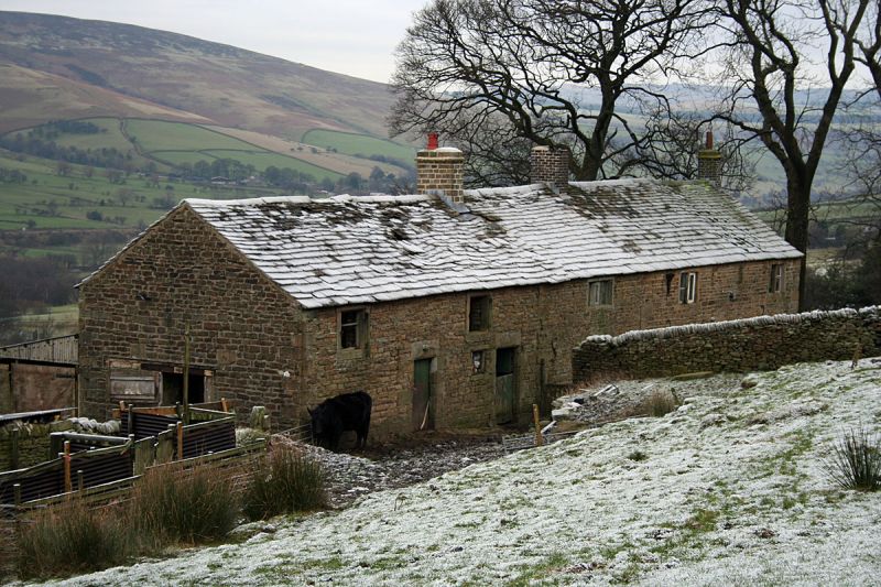
Farmhouse and attached barn under one roof. Early C17 and C18. Rubble gritstone
with gritstone dressings and quoins. Stone slate roof with stone ridge stack, brick
ridge stack and a brick gable end stack. Two storeys. South elevation of five
irregular bays. House to the right. The earliest part adjoins the barn and has a
4-light recessed and chamfered mullion window with a similar 3-light window above.
Quoins to the right mark the beginning of the double fronted C18 part which has a
central doorway with quoins and lintel and plank door, flanked on each side by
2-light square section mullion windows. Two similar windows above. The barn has
two doorways with quoins and lintels and plank doors and a small window opening
between. Two square openings above with flush stone surrounds.
Listing NGR: SK1322984785
External links are from the relevant listing authority and, where applicable, Wikidata. Wikidata IDs may be related buildings as well as this specific building. If you want to add or update a link, you will need to do so by editing the Wikidata entry.


Other nearby listed buildings
