Latitude: 50.6003 / 50°36'0"N
Longitude: -2.4589 / 2°27'31"W
OS Eastings: 367621
OS Northings: 77939
OS Grid: SY676779
Mapcode National: GBR PY.F21M
Mapcode Global: FRA 57QH.5VQ
Plus Code: 9C2VJG2R+4F
Entry Name: Number 2 with Boundary Wall and Gate Piers
Listing Date: 14 June 1974
Last Amended: 22 December 1997
Grade: II
Source: Historic England
Source ID: 1096762
English Heritage Legacy ID: 467773
ID on this website: 101096762
Location: Rodwell, Dorset, DT4
County: Dorset
Electoral Ward/Division: Weymouth East
Parish: Weymouth
Built-Up Area: Weymouth
Traditional County: Dorset
Lieutenancy Area (Ceremonial County): Dorset
Church of England Parish: Weymouth Holy Trinity
Church of England Diocese: Salisbury
Tagged with: Building
WEYMOUTH
SY67NE OLD CASTLE ROAD 873-1/4/241 (West side) 14/06/74 No.2 with boundary wall and gate piers (Formerly Listed as: OLD CASTLE ROAD No.2)
II
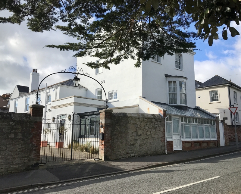
Detached villa. Early C19. Rendered, slate roofs. A tall but narrow-fronted detached house facing the street, with a lower service range attached to and set back to the left; all enclosed by a boundary wall. EXTERIOR: principal range in 3 storeys; at second floor are two 16-pane sashes in deep reveals, above a 2-storey central bow with 8:12:8-pane sashes and dentil cornice. Ground floor is enclosed by a late C19 glazed verandah on a low brick panelled wall, and incorporating a contemporary glazed door with margin panes to the left; opposite this, in the original wall plane, is a similar door, with margin panes, side-lights, and transom light. The glazed verandah roof continues above a rubble stone wall, and returns, by a hipped end, to the left gable end, which has a plain sash at first and second floors, plus a 2-light small-pane casement at the first floor, and a glazed verandah front. The street front has a moulded stone cornice and blocking course, and the parapet returns at each end to a central gable. The right return is plain, with a large brick stack. The rear wall has a 4-pane sash in deep reveals, to a slight cambered head; this front also has parapet and coping. The former service wing is hipped, in 2 storeys and with 3 windows, all plain sash, but at the right-hand end, near the main range, is a 2-light small-pane casement at first floor level, and a similar opening below. A large stack at the outer end. INTERIOR: not inspected. SUBSIDIARY FEATURES: the stone wall to the left of the verandah continues a short distance to a square gate pier with pyramidal capping, and beyond the opening with plank gateway a further pier and length of wall approx 2.7m high, with saddle-back coping, across the full width of the site. To the right of the frontage the boundary wall continues in garden wall bond brickwork incorporating a plank gateway, and returning along the flanks and rear of the site.
An earlier survival in an area mostly developed in the later C19 and early C20.
Listing NGR: SY6762177939
External links are from the relevant listing authority and, where applicable, Wikidata. Wikidata IDs may be related buildings as well as this specific building. If you want to add or update a link, you will need to do so by editing the Wikidata entry.


Other nearby listed buildings