Approximate Location Map
Large Map »
Latitude: 52.8318 / 52°49'54"N
Longitude: -1.3731 / 1°22'23"W
OS Eastings: 442334
OS Northings: 326210
OS Grid: SK423262
Mapcode National: GBR 7HH.FP7
Mapcode Global: WHDHF.W2BY
Plus Code: 9C4WRJJG+PQ
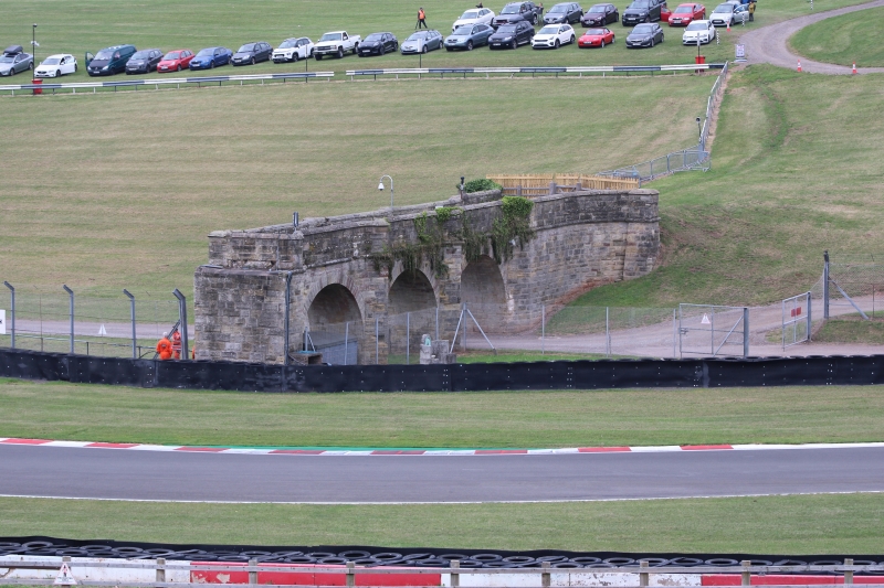
Entry Name: Starkeys Bridge
Listing Date: 4 July 1972
Grade: II
Source: Historic England
Source ID: 1101518
English Heritage Legacy ID: 358109
ID on this website: 101101518
Location: Isley Walton, North West Leicestershire, DE74
County: Leicestershire
District: North West Leicestershire
Civil Parish: Castle Donington
Traditional County: Leicestershire
Lieutenancy Area (Ceremonial County): Leicestershire
Church of England Parish: Castle Donington St Edward the King and Martyr
Church of England Diocese: Leicester
Tagged with: Bridge
CASTLE DONINGTON DONINGTON PARK
SK 42 NW
2/62 Starkey's Bridge
4.7.72
- II
Bridge, built as a garden feature. Dated 1834 on tablet over central arch on
north west side. Ashlar, slightly rusticated. 3 semi-circular arches on piers
with full-height cut waters to both sides. Coped parapet with moulded string.
At north east end walls curve out to battered piers, with retaining wall contin-
uing for short distance beyond pier on north side. Bridge terminates abruptly
to south west at edge of Donington Park race track.
Listing NGR: SK4233426210
External links are from the relevant listing authority and, where applicable, Wikidata. Wikidata IDs may be related buildings as well as this specific building. If you want to add or update a link, you will need to do so by editing the Wikidata entry.


Other nearby listed buildings
