Approximate Location Map
Large Map »
Latitude: 51.7602 / 51°45'36"N
Longitude: -0.1003 / 0°6'1"W
OS Eastings: 531205
OS Northings: 208537
OS Grid: TL312085
Mapcode National: GBR KC2.RF8
Mapcode Global: VHGPV.60TZ
Plus Code: 9C3XQV6X+3V
Entry Name: The Manor House
Listing Date: 20 October 1952
Grade: II
Source: Historic England
Source ID: 1101710
English Heritage Legacy ID: 160618
ID on this website: 101101710
Location: Bayford, East Hertfordshire, SG13
County: Hertfordshire
District: East Hertfordshire
Civil Parish: Bayford
Built-Up Area: Bayford
Traditional County: Hertfordshire
Lieutenancy Area (Ceremonial County): Hertfordshire
Church of England Parish: Bayford
Church of England Diocese: St.Albans
Tagged with: House
TL 3108 BAYFORD BAYFORD GREEN
(East side)
6/10 No. 6
20.10.52 (The Manor House)
GV II
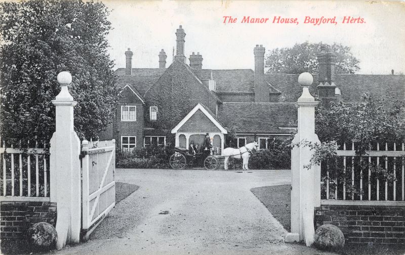
Manor house. Late medieval, a royal manor granted 1547 to John Knighton
(N part of E range) who added before 1583 kitchen block (S end of E
range), called Bayford Place by 1613, early C17 W wing, enlarged and
brick cased 1655-1662 for John Mayo, became a farmhouse after
Sir William baker bought the manor in 1758 and then built Bayfordbury,
altered and extended as private house c.1912 for Mrs. Barclay, with new
entrance on W. Timber frame encased in red brick of various periods and
red tilehanging. Steep old red tile roofs. A large irregular T-shaped
building in its own grounds facing E but with entrance now into
1½-storeys and 2-storeys W part with tile-hung gables small-pane
casements, transomed ground floor windows and arcaded open timber porch.
E front in 3 parts, the middle containing later medieval house with
clasped-purlin roof. N part of low single-storey with N gable chimney,
one window and door near S end of front. 1½-storeys middle part has
internal N gable chimney to large open fireplace of former hall, 3
windows long with gabled dormers rising through the eaves, leaded
casements, bargeboards, and red tilehanging above ground floor windows.
Canted bay window and half-glazed door with flat hood. S part has
massive front-wall projecting chimney, 2-storeys canted bay to RH and
gabled dormer on roofslope above. One window on each floor to LH. S end
has tilehung gable triangle with bands of serrated and plain tiles.
Moulded bargeboards, casement windows, and canted bay-window with French
doors. W side of this S end has old narrow red brickwork in
English-bond. Interior has exposed timber frame in S end, fine oak
staircase c.1660 with closed string, turned balusters, heavy moulded
rail, rusticated square newels and openwork pierced finials and
pendants, serving 3 floors. C19 main staircase with stick balusters, and
wreathed handrail. Panelling in room on 1st floor painted with strapwork
decoration. Wall in cupboard near rear door has pump mechanism with
large flywheel. Buckler drawing 1848 in HRO shows a large building
immediately to W since demolished. (RCHM (1911)49: VCH (1912)420: RCHM
Typescript).
Listing NGR: TL3120508537
External links are from the relevant listing authority and, where applicable, Wikidata. Wikidata IDs may be related buildings as well as this specific building. If you want to add or update a link, you will need to do so by editing the Wikidata entry.


Other nearby listed buildings
