Approximate Location Map
Large Map »
Latitude: 51.9903 / 51°59'25"N
Longitude: -0.1902 / 0°11'24"W
OS Eastings: 524367
OS Northings: 233977
OS Grid: TL243339
Mapcode National: GBR J6Y.0S1
Mapcode Global: VHGNM.N7BK
Plus Code: 9C3XXRR5+4W
Entry Name: 3 and 5, Church Street
Listing Date: 8 November 1949
Grade: II*
Source: Historic England
Source ID: 1102135
English Heritage Legacy ID: 161614
ID on this website: 101102135
Location: Baldock, North Hertfordshire, SG7
County: Hertfordshire
District: North Hertfordshire
Electoral Ward/Division: Baldock Town
Parish: Non Civil Parish
Built-Up Area: Baldock
Traditional County: Hertfordshire
Lieutenancy Area (Ceremonial County): Hertfordshire
Church of England Parish: Baldock
Church of England Diocese: St.Albans
Tagged with: Building
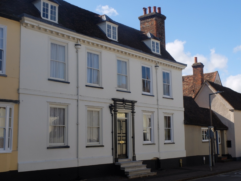
CHURCH STREET
1. (South West Side)
5255 -----------------
8.ll.9. No 3
- No 5
TL 2433 NW 1/32
II* GV
2.
Cl8 front of plaster steeply pitched tiled roof with 3 hipped casement
dormers and modillioned cornice. 2 storeys, 5 sash windows in slightly
recessed broad frames. 5 stone steps up to 6 fielded panelled door in
surround of fluted pilasters, entablature ever rectangular fanlight.
First floor band. Canted bay window on left of ground floor.
The Church of Saint Mary, Churchyard Wall of Saint Mary's and Nos 1 to
13 (odd) form a group.
Listing NGR: TL2436733977
External links are from the relevant listing authority and, where applicable, Wikidata. Wikidata IDs may be related buildings as well as this specific building. If you want to add or update a link, you will need to do so by editing the Wikidata entry.


Other nearby listed buildings
